5 years ago

NEWPORT BEACH, California (AP) — Hundreds of giant squid are washing up on Orange County beaches, creating a scene more akin to “20,000 Leagues Under the Sea” than “The O.C.”
The bug-eyed sea creatures, believed to be Humboldt squid, normally reside in deep water and only come to the surface at night. Why approximately 500 of them began washing up on the sands of Laguna Beach and Newport Beach on Tuesday isn’t clear.
Authorities said the squid — the biggest weighing 17 pounds — might have been pursuing bait fish and gotten too close to shore, or the tides might simply have carried them in.
“I have heard of this happening before, but it’s not a common occurrence,” lifeguard Capt. Eric Bauer of the Newport Beach Fire Department said Wednesday.
Authorities plan to remove the squid in the next couple of days and will give at least a couple to the Santa Barbara Museum of Natural History for research.
In the meantime, beachgoers were advised not to eat or even touch them. “They probably have bacteria on them at this point,” Bauer said.
5 years ago
Mount St. Helens blasts rocks, ash into the air
Mount St. Helens blasts rocks, ash into the air
Seattle Post Intelligencer – Seattle,WA,USA
... rocks and ash from the north end of its still-growing lava dome, sending a dusting of ash nearly 2 miles from the crater of the southwest Washington volcano. ...
5 years ago

Alabama
High Wind Advisory
Cullman County, De Kalb County, Jackson County, Marshall County, Morgan County, Madison County, Limestone County, Lawrence County, Franklin County, Colbert County, Lauderdale County, Barbour County, Pike County, Russell County, Lee County, Bullock County, Macon County, Montgomery County, Elmore County, Lowndes County, Autauga County, Dallas County, Marengo County, Chambers County, Tallapoosa County, Coosa County, Chilton County, Bibb County, Perry County, Hale County, Greene County, Sumter County, Randolph County, Clay County, Talladega County, St. Clair County, Shelby County, Jefferson County, Tuscaloosa County, Pickens County, Cleburne County, Cherokee County, Calhoun County, Etowah County, Blount County, Walker County, Winston County, Fayette County, Lamar County, Marion County
Dense Fog Advisory
Lower Baldwin County, Lower Mobile County, Upper Baldwin County, Upper Mobile County, Covington County, Escambia County, Conecuh County, Monroe County, Clarke County, Washington County, Houston County, Geneva County, Henry County, Dale County, Coffee County
Arkansas
High Wind Advisory
St. Francis County, Crittenden County, Cross County, Mississippi County, Poinsett County, Craighead County, Greene County, Lawrence County, Clay County, Randolph County, Drew County, Bradley County, Calhoun County, Ouachita County, Desha County, Lincoln County, Cleveland County, Dallas County, Arkansas County, Jefferson County, Grant County, Hot Spring County, Clark County, Pike County, Monroe County, Prairie County, Lonoke County, Pulaski County, Saline County, Garland County, Montgomery County, Polk County, Perry County, Yell County, Scott County, Woodruff County, White County, Faulkner County, Conway County, Logan County, Jackson County, Cleburne County, Van Buren County, Pope County, Johnson County, Independence County, Izard County, Stone County, Searcy County, Newton County, Sharp County, Fulton County, Baxter County, Marion County, Boone County, Chicot County, Ashley County
Flood Watch / Flood Statement
Phillips County, Lee County, Crittenden County, Mississippi County, Union County, Woodruff County, Jackson County, Arkansas County, Monroe County, Prairie County, White County, Chicot County, Desha County
California
Winter Weather Statement
Greater Lake Tahoe Area, Lassen-Eastern Plumas-Eastern Sierra Counties
Dense Fog Advisory
San Diego County Valleys, San Diego County Coastal Areas, Orange County Coastal Areas
Colorado
Dense Fog Advisory
Lower Yampa River Basin
Connecticut
Winter Weather Statement
Windham County, Tolland County, Hartford County, Northern Litchfield County, Southern New London County, Southern Middlesex County, Southern New Haven County, Southern Fairfield County, Northern New London County, Northern Middlesex County, Northern New Haven County, Northern Fairfield County
Flood Watch / Flood Statement
Southern New London County, Southern Middlesex County, Southern New Haven County, Southern Fairfield County
Delaware
Winter Weather Statement
Kent County, New Castle County, Delaware Beaches County, Inland Sussex County
District of Columbia
Winter Weather Statement
District of Columbia
Florida
Winter Weather Statement
Martin County, St. Lucie County, Okeechobee County, Indian River County, Osceola County, Southern Brevard County, Seminole County, Orange County, Northern Lake County, Inland Volusia County, Western Broward County, Eastern Collier County, Western Collier County, Palm Beach Western County, Hendry County, Glades County, Hernando County, Sumter County, Citrus County, Levy County, Lee County, Charlotte County, De Soto County, Sarasota County, Highlands County, Hardee County, Manatee County, Polk County, Hillsborough County, Pinellas County, Pasco County
Dense Fog Advisory
Coastal Okaloosa County, Inland Okaloosa County, Coastal Santa Rosa County, Inland Santa Rosa County, Coastal Escambia County, Inland Escambia County, Lee County, Charlotte County, De Soto County, Sarasota County, Highlands County, Hardee County, Manatee County, Polk County, Hillsborough County, Pinellas County, Pasco County, Hernando County, Sumter County, Citrus County, Levy County, Marion County, Flagler County, Putnam County, Alachua County, Gilchrist County, St. Johns County, Clay County, Bradford County, Union County, Duval County, Nassau County, Baker County, Columbia County, Suwannee County, Hamilton County, Dixie County, Lafayette County, Taylor County, Wakulla County, Liberty County, Madison County, Jefferson County, Leon County, Gadsden County, Franklin County, Gulf County, Calhoun County, Bay County, Jackson County, Washington County, Holmes County, Coastal Walton County, Inland Walton County, Mainland Monroe County, Western Dade County, Western Broward County, Eastern Collier County, Western Collier County, Palm Beach Western County, Hendry County, Glades County
Georgia
High Wind Advisory
Toombs County, Montgomery County, Wheeler County, Telfair County, Dodge County, Wilcox County, Pulaski County, Crisp County, Dooly County, Sumter County, Webster County, Stewart County, Treutlen County, Laurens County, Bleckley County, Houston County, Peach County, Macon County, Schley County, Marion County, Chattahoochee County, Muscogee County, Emanuel County, Johnson County, Wilkinson County, Twiggs County, Bibb County, Crawford County, Taylor County, Talbot County, Harris County, Jefferson County, Glascock County, Washington County, Baldwin County, Jones County, Monroe County, Lamar County, Upson County, Pike County, Meriwether County, Troup County, Warren County, Hancock County, Putnam County, Jasper County, Butts County, Henry County, Spalding County, Clayton County, Fayette County, Coweta County, Heard County, Taliaferro County, Greene County, Morgan County, Newton County, Walton County, Rockdale County, De Kalb County, South Fulton County, Douglas County, Carroll County, Haralson County, Wilkes County, Oglethorpe County, Oconee County, Clarke County, Barrow County, Gwinnett County, North Fulton County, Cobb County, Paulding County, Polk County, Madison County, Jackson County, Banks County, Hall County, Forsyth County, Cherokee County, Bartow County, Floyd County, White County, Lumpkin County, Dawson County, Pickens County, Gordon County, Chattooga County, Towns County, Union County, Gilmer County, Fannin County, Murray County, Whitfield County, Catoosa County, Walker County, Dade County, Burke County, Richmond County, Columbia County, McDuffie County, Lincoln County
Dense Fog Advisory
Lanier County, Lowndes County, Brooks County, Thomas County, Grady County, Decatur County, Seminole County, Berrien County, Cook County, Colquitt County, Mitchell County, Baker County, Miller County, Early County, Irwin County, Ben Hill County, Tift County, Turner County, Worth County, Lee County, Dougherty County, Terrell County, Calhoun County, Randolph County, Clay County, Quitman County
Idaho
Dense Fog Advisory
Western Magic Valley, Eastern Lemhi County, Wasatch Mountains/Idaho Portion, Cache Valley/Idaho Portion, Lower Snake River Plain, Upper Snake River Plain, Eastern Magic Valley
Illinois
High Wind Advisory
Monroe County, St. Clair County, Madison County, Jersey County, Calhoun County, Pike County, Brown County, Adams County, Randolph County, Washington County, Marion County, Clinton County, Fayette County, Bond County, Montgomery County, Macoupin County, Greene County, Lawrence County, Richland County, Clay County, Crawford County, Jasper County, Effingham County, Clark County, Cumberland County, Shelby County, Edgar County, Coles County, Douglas County, Moultrie County, Macon County, Christian County, Sangamon County, Morgan County, Scott County, Menard County, Cass County, Logan County, Mason County, Schuyler County, Fulton County, Massac County, Pulaski County, Alexander County, Hardin County, Pope County, Johnson County, Union County, Gallatin County, Saline County, Williamson County, Jackson County, White County, Hamilton County, Franklin County, Perry County, Wabash County, Edwards County, Wayne County, Jefferson County, McDonough County, Hancock County, Warren County, Henderson County, Mercer County, Putnam County, Bureau County, Henry County, Rock Island County
Winter Weather Statement
Vermilion County, Champaign County, Piatt County, De Witt County, McLean County, Tazewell County, Woodford County, Marshall County, Peoria County, Stark County, Knox County, Whiteside County, Carroll County, Stephenson County, Jo Daviess County, Mercer County, Henry County, Rock Island County, Putnam County, Bureau County
Flood Watch / Flood Statement
Massac County, Pulaski County, Alexander County, Hardin County, Pope County, Gallatin County, White County, Wabash County, Wayne County, Williamson County, Jackson County, Franklin County, Clinton County, Jersey County, Calhoun County, Pike County, Brown County, Morgan County, Scott County, Sangamon County, Cass County, Mason County, Schuyler County, Tazewell County, Fulton County, Woodford County, Marshall County, Peoria County, Putnam County, Bureau County, La Salle County
Flood Warning
Lawrence County, Crawford County, Clark County
Indiana
High Wind Advisory
Clark County, Floyd County, Harrison County, Perry County, Crawford County, Dubois County, Jefferson County, Scott County, Washington County, Orange County, Spencer County, Warrick County, Vanderburgh County, Posey County, Pike County, Gibson County
Winter Weather Statement
Jay County, Blackford County, Grant County, Adams County, Wells County, Huntington County, Wabash County, Miami County, Cass County, White County, Fulton County, Pulaski County, Allen County, Whitley County, Kosciusko County, Marshall County, Starke County, De Kalb County, Noble County, Steuben County, Lagrange County, Elkhart County, St. Joseph County, La Porte County, Clark County, Floyd County, Jefferson County, Scott County, Switzerland County, Ohio County, Dearborn County, Ripley County, Wayne County, Franklin County, Union County, Fayette County, Decatur County, Rush County, Shelby County, Johnson County, Morgan County, Hancock County, Marion County, Hendricks County, Putnam County, Parke County, Vermillion County, Boone County, Montgomery County, Fountain County, Warren County, Henry County, Randolph County, Delaware County, Madison County, Hamilton County, Tipton County, Howard County, Clinton County, Tippecanoe County, Carroll County
Flood Watch / Flood Statement
Spencer County, Warrick County, Vanderburgh County, Posey County, Gibson County, Allen County, De Kalb County, Wabash County, Miami County, Cass County, Carroll County, White County, Kosciusko County, Fulton County, Pulaski County, Starke County, St. Joseph County, La Porte County, Perry County, Jasper County, Newton County, Porter County, Lake County
Iowa
High Wind Advisory
Page County, Fremont County, Montgomery County, Mills County, Pottawattamie County, Shelby County, Harrison County, Monona County, Woodbury County, Plymouth County, Sioux County, Lyon County, Ida County, Buena Vista County, Cherokee County, Clay County, O’Brien County, Dickinson County, Osceola County, Davis County, Appanoose County, Wayne County, Decatur County, Ringgold County, Taylor County, Wapello County, Monroe County, Lucas County, Clarke County, Union County, Adams County, Mahaska County, Marion County, Warren County, Madison County, Adair County, Cass County, Poweshiek County, Jasper County, Polk County, Dallas County, Guthrie County, Audubon County, Tama County, Marshall County, Story County, Boone County, Greene County, Carroll County, Crawford County, Black Hawk County, Grundy County, Hardin County, Hamilton County, Webster County, Calhoun County, Sac County, Franklin County, Wright County, Humboldt County, Pocahontas County, Palo Alto County, Kossuth County, Emmet County, Lee County, Van Buren County, Des Moines County, Henry County, Jefferson County, Louisa County, Washington County, Keokuk County, Scott County, Muscatine County, Cedar County, Johnson County, Iowa County, Linn County, Benton County
Winter Weather Statement
Bremer County, Butler County, Cerro Gordo County, Hancock County, Worth County, Winnebago County, Clayton County, Fayette County, Allamakee County, Winneshiek County, Chickasaw County, Floyd County, Howard County, Mitchell County, Clinton County, Jackson County, Jones County, Linn County, Benton County, Dubuque County, Delaware County, Buchanan County, Scott County, Muscatine County, Cedar County, Johnson County, Iowa County
Kansas
High Wind Advisory
Anderson County, Coffey County, Franklin County, Osage County, Lyon County, Douglas County, Shawnee County, Wabaunsee County, Jefferson County, Jackson County, Pottawatomie County, Brown County, Nemaha County, Riley County, Clay County, Cloud County, Marshall County, Washington County, Republic County, Morris County, Geary County, Dickinson County, Ottawa County, Johnson County, Wyandotte County, Leavenworth County, Doniphan County, Linn County, Miami County, Atchison County
Kentucky
High Wind Advisory
Clinton County, Cumberland County, Russell County, Adair County, Metcalfe County, Monroe County, Barren County, Allen County, Simpson County, Warren County, Logan County, Lincoln County, Casey County, Taylor County, Green County, Hart County, Edmonson County, Butler County, Madison County, Garrard County, Boyle County, Marion County, Larue County, Clark County, Jessamine County, Mercer County, Washington County, Nelson County, Nicholas County, Bourbon County, Fayette County, Woodford County, Anderson County, Spencer County, Harrison County, Scott County, Franklin County, Shelby County, Henry County, Trimble County, Oldham County, Jefferson County, Bullitt County, Hardin County, Grayson County, Ohio County, Meade County, Breckinridge County, Hancock County, Todd County, Muhlenberg County, McLean County, Daviess County, Henderson County, Christian County, Hopkins County, Webster County, Union County, Caldwell County, Trigg County, Lyon County, Crittenden County, Calloway County, Marshall County, Livingston County, Graves County, McCracken County, Ballard County, Carlisle County, Hickman County, Fulton County
Winter Weather Statement
Lincoln County, Madison County, Garrard County, Boyle County, Clark County, Jessamine County, Mercer County, Washington County, Nelson County, Nicholas County, Bourbon County, Fayette County, Woodford County, Anderson County, Spencer County, Harrison County, Scott County, Franklin County, Shelby County, Henry County, Trimble County, Oldham County, Jefferson County, Bullitt County, Campbell County, Kenton County, Boone County, Lewis County, Mason County, Robertson County, Bracken County, Pendleton County, Grant County, Owen County, Gallatin County, Carroll County, Martin County, Breathitt County, Lee County, Magoffin County, Wolfe County, Johnson County, Morgan County, Elliott County, Menifee County, Powell County, Estill County, Rowan County, Bath County, Montgomery County, Fleming County
Flood Watch / Flood Statement
Daviess County, Henderson County, Union County, Crittenden County, Livingston County, McCracken County, Ballard County, Carlisle County, Hickman County, Fulton County, Muhlenberg County, McLean County, Webster County, Breckinridge County, Hancock County
Flood Warning
Muhlenberg County, McLean County, Webster County
Louisiana
High Wind Advisory
Lower St. Bernard Parish, Lower Plaquemines Parish, Lower Jefferson Parish, Lower Lafourche Parish, Lower Terrebonne Parish, Upper Terrebonne Parish, Upper St. Bernard Parish, Upper Plaquemines Parish, Orleans Parish, Upper Jefferson Parish, St. Charles Parish, Upper Lafourche Parish, St. John The Baptist Parish, Concordia Parish, Tensas Parish, Catahoula Parish, Franklin Parish, Madison Parish, Richland Parish, East Carroll Parish, West Carroll Parish, Morehouse Parish
Flood Watch / Flood Statement
St. John The Baptist Parish, Ascension Parish, East Baton Rouge Parish, West Baton Rouge Parish, West Feliciana Parish, Pointe Coupee Parish, St. Mary Parish, Webster Parish, Concordia Parish, Tensas Parish, Madison Parish, East Carroll Parish
Maine
Winter Weather Statement
Coastal Cumberland County, Coastal York County, Interior Cumberland County, Interior York County, Coastal Waldo County, Knox County, Lincoln County, Sagadahoc County, Interior Waldo County, Kennebec County, Androscoggin County, Coastal Washington County, Coastal Hancock County, Central Washington County, Interior Hancock County, Southern Penobscot County, Central Penobscot County, Northern Piscataquis County, Northern Somerset County, Northeast Aroostook County, Northwest Aroostook County, Central Piscataquis County, Southeast Aroostook County, Northern Penobscot County
Maryland
Winter Weather Statement
Queen Anne’s County, Kent County, Cecil County, Caroline County, Talbot County, Garrett County, Calvert County, St. Marys County, Charles County, Anne Arundel County, Prince Georges County, Southern Baltimore County, Howard County, Montgomery County, Harford County, Northern Baltimore County, Carroll County, Frederick County, Washington County, Allegany County, Maryland Beaches County, Inland Worcester County, Somerset County, Wicomico County, Dorchester County
Massachusetts
Winter Weather Statement
Eastern Hampshire County, Western Hampshire County, Northern Worcester County, Eastern Franklin County, Western Franklin County, Nantucket County, Dukes County, Barnstable County, Southern Plymouth County, Southern Bristol County, Eastern Plymouth County, Western Plymouth County, Northern Bristol County, Eastern Norfolk County, Suffolk County, Southeast Middlesex County, Western Norfolk County, Eastern Essex County, Southern Worcester County, Eastern Hampden County, Western Hampden County, Western Essex County, Central Middlesex County, Northern Berkshire County
Michigan
Winter Weather Statement
Hillsdale County, Branch County, St. Joseph County, Cass County, Berrien County, Gladwin County, Roscommon County, Missaukee County, Wexford County, Manistee County, Crawford County, Kalkaska County, Grand Traverse County, Benzie County, Otsego County, Antrim County, Leelanau County, Charlevoix County, Emmet County, Arenac County, Iosco County, Ogemaw County, Alcona County, Oscoda County, Alpena County, Montmorency County, Presque Isle County, Cheboygan County, Southern Schoolcraft County, Delta County, Menominee County, Dickinson County, Iron County, Marquette County, Baraga County, Gogebic County, Ontonagon County, Alger County, Northern Houghton County, Keweenaw County, Gratiot County, Montcalm County, Isabella County, Mecosta County, Newaygo County, Oceana County, Clare County, Osceola County, Lake County, Mason County, Jackson County, Calhoun County, Kalamazoo County, Van Buren County, Eaton County, Barry County, Allegan County, Ionia County, Kent County, Ottawa County, Muskegon County, Ingham County, Clinton County, Saginaw County, Bay County, Midland County, St. Clair County, Sanilac County, Huron County, Monroe County, Lenawee County, Wayne County, Washtenaw County, Macomb County, Oakland County, Livingston County, Tuscola County, Genesee County, Shiawassee County, Lapeer County, Mackinac County
Flood Watch / Flood Statement
Allegan County, Ottawa County, Kent County, Monroe County
Flood Warning
Ottawa County
Minnesota
High Wind Advisory
Nobles County, Murray County, Lyon County, Lincoln County, Rock County, Pipestone County, Jackson County, Cottonwood County
Winter Weather Statement
Pine County, Carlton/South St. Louis County, South Aitkin County, Northern Aitkin County, Crow Wing County, South Cass County, South Itasca County, North Cass County, Central St. Louis County, Southern Cook/North Shore County, Southern Lake/North Shore County, Northern Cook/Northern Lake County, Big Stone County, Traverse County, Freeborn County, Faribault County, Martin County, Steele County, Waseca County, Blue Earth County, Watonwan County, Rice County, Le Sueur County, Nicollet County, Brown County, Redwood County, Sibley County, McLeod County, Renville County, Yellow Medicine County, Meeker County, Kandiyohi County, Chippewa County, Swift County, Lac Qui Parle County, Pope County, Stevens County, Douglas County, Goodhue County, Dakota County, Scott County, Carver County, Washington County, Ramsey County, Anoka County, Hennepin County, Wright County, Chisago County, Isanti County, Sherburne County, Benton County, Stearns County, Kanabec County, Mille Lacs County, Morrison County, Todd County, South Beltrami County, North Clearwater County, North Beltrami County, Lake Of The Woods County, Wadena County, East Becker County, Hubbard County, South Clearwater County, Grant County, East Otter Tail County, West Otter Tail County, Wilkin County, West Becker County, Mahnomen County, East Polk County, Red Lake County, Pennington County, East Marshall County, West Marshall County, Roseau County, Kittson County, Clay County, Norman County, West Polk County, Houston County, Winona County, Wabasha County, Fillmore County, Mower County, Olmsted County, Dodge County
Mississippi
High Wind Advisory
Forrest County, Lamar County, Marion County, Jones County, Covington County, Jefferson Davis County, Lawrence County, Lincoln County, Franklin County, Adams County, Jefferson County, Clarke County, Jasper County, Smith County, Simpson County, Copiah County, Claiborne County, Lauderdale County, Newton County, Scott County, Rankin County, Hinds County, Kemper County, Neshoba County, Leake County, Madison County, Noxubee County, Winston County, Attala County, Oktibbeha County, Choctaw County, Lowndes County, Clay County, Webster County, Montgomery County, Carroll County, Grenada County, Warren County, Yazoo County, Sharkey County, Issaquena County, Holmes County, Humphreys County, Washington County, Leflore County, Sunflower County, Bolivar County
Flood Watch / Flood Statement
Tallahatchie County, Coahoma County, Tunica County, De Soto County, Wilkinson County, Adams County, Jefferson County, Claiborne County, Warren County, Issaquena County, Washington County, Bolivar County, Yazoo County
Dense Fog Advisory
George County, Stone County, Greene County, Perry County
Missouri
High Wind Advisory
Pemiscot County, Dunklin County, Reynolds County, Madison County, Iron County, Ste. Genevieve County, St. Francois County, Washington County, Crawford County, Jefferson County, St. Louis City County, St. Louis County, Franklin County, St. Charles County, Warren County, Gasconade County, Lincoln County, Montgomery County, Callaway County, Osage County, Cole County, Moniteau County, Audrain County, Boone County, Pike County, Ralls County, Monroe County, Marion County, Shelby County, Lewis County, Knox County, Dent County, Phelps County, Pulaski County, Camden County, Hickory County, St. Clair County, Maries County, Miller County, Morgan County, Benton County, New Madrid County, Mississippi County, Scott County, Stoddard County, Butler County, Ripley County, Carter County, Wayne County, Cape Girardeau County, Bollinger County, Perry County, Henry County, Bates County, Cooper County, Pettis County, Johnson County, Cass County, Howard County, Saline County, Lafayette County, Jackson County, Randolph County, Chariton County, Carroll County, Ray County, Clay County, Platte County, Macon County, Linn County, Livingston County, Caldwell County, Clinton County, Buchanan County, Adair County, Sullivan County, Grundy County, Daviess County, De Kalb County, Andrew County, Holt County, Schuyler County, Putnam County, Mercer County, Harrison County, Gentry County, Worth County, Nodaway County, Atchison County, Clark County, Scotland County
Flood Watch / Flood Statement
Mississippi County, New Madrid County, Pemiscot County
Montana
High Wind Advisory
Northern Rocky Mountain Front
Winter Weather Statement
Central and Southern Valley County
Dense Fog Advisory
Missoula/Bitterroot Valleys
Nebraska
High Wind Advisory
Richardson County, Pawnee County, Nemaha County, Johnson County, Gage County, Jefferson County, Saline County, Otoe County, Cass County, Lancaster County, Seward County, Sarpy County, Douglas County, Saunders County, Butler County, Washington County, Dodge County, Colfax County, Platte County, Burt County, Cuming County, Stanton County, Madison County, Boone County, Wayne County, Pierce County, Antelope County, Thurston County, Cedar County, Knox County, Thayer County, Nuckolls County, Fillmore County, Clay County, Adams County, York County, Hamilton County, Hall County, Buffalo County, Polk County, Merrick County, Howard County, Sherman County, Nance County, Greeley County, Valley County, Dakota County, Dixon County
Nevada
Winter Weather Statement
Greater Lake Tahoe Area, Mineral and Southern Lyon Counties, Northern Washoe County, Western Nevada Basin and Range including Pyramid Lake, Greater Reno-Carson City-Minden Area, Northern Lander County and Northern Eureka County, Extreme Eastern Elko County, Southwest and South Central Elko County, Northern Elko County, Humboldt County
New Hampshire
Winter Weather Statement
Coastal Rockingham County, Interior Rockingham County, Strafford County, Belknap County, Merrimack County, Sullivan County, Southern Carroll County, Southern Grafton County, Eastern Hillsborough County, Cheshire County
New Jersey
Winter Weather Statement
Atlantic County, Cumberland County, Coastal Ocean County, Ocean County, Northwestern Burlington County, Camden County, Gloucester County, Salem County, Mercer County, Eastern Monmouth County, Western Monmouth County, Middlesex County, Somerset County, Hunterdon County, Morris County, Warren County, Sussex County, Coastal Atlantic County, Atlantic Coastal Cape May County, Cape May County, Western Passaic County, Union County, Hudson County, Essex County, Eastern Passaic County, Bergen County
Flood Watch / Flood Statement
Coastal Ocean County, Coastal Atlantic County, Atlantic Coastal Cape May County, Cape May County, Atlantic County, Ocean County, Eastern Monmouth County, Western Monmouth County, Middlesex County, Hudson County
New Mexico
High Wind Advisory
Guadalupe Mountains of Eddy County
New York
Winter Weather Statement
Delaware County, Broome County, Tioga County, Otsego County, Chenango County, Cortland County, Tompkins County, Chemung County, Schuyler County, Steuben County, Yates County, Southern Oneida County, Madison County, Onondaga County, Southern Cayuga County, Seneca County, Sullivan County, Northern Oneida County, Lewis County, Jefferson County, Oswego County, Northern Cayuga County, Monroe County, Orleans County, Niagara County, Ontario County, Livingston County, Wyoming County, Genesee County, Northern Erie County, Wayne County, Allegany County, Cattaraugus County, Chautauqua County, Hamilton County, Northern Herkimer County, Northern Washington County, Northern Warren County, Northern Saratoga County, Montgomery County, Southern Fulton County, Southern Herkimer County, Eastern Dutchess County, Western Dutchess County, Eastern Ulster County, Western Ulster County, Eastern Columbia County, Western Columbia County, Eastern Greene County, Western Greene County, Eastern Rensselaer County, Western Rensselaer County, Eastern Albany County, Western Albany County, Southern Saratoga County, Eastern Schenectady County, Western Schenectady County, Schoharie County, Western Clinton County, Southern Franklin County, Southeastern St. Lawrence County, Eastern Essex County, Western Essex County, Southeast Suffolk County, Southwest Suffolk County, Northeast Suffolk County, Northwest Suffolk County, Nassau County, Queens County, Kings (Brooklyn) County, Richmond (Staten Is.) County, Bronx County, New York (Manhattan) County, Southern Westchester County, Northern Westchester County, Rockland County, Putnam County, Orange County
Flood Watch / Flood Statement
Southeast Suffolk County, Southwest Suffolk County, Kings (Brooklyn) County, Richmond (Staten Is.) County, New York (Manhattan) County, Northeast Suffolk County, Northwest Suffolk County, Nassau County, Queens County, Bronx County, Southern Westchester County
North Carolina
High Wind Advisory
Henderson County, Transylvania County, Southern Jackson County, Macon County, Northern Jackson County, Graham County, Buncombe County, Haywood County, Swain County, Mitchell County, Yancey County, Madison County, Avery County, Wilkes County, Surry County, Watauga County, Alleghany County, Ashe County, Clay County, Cherokee County
Winter Weather Statement
Watauga County, Ashe County, Alleghany County, Yadkin County, Wilkes County, Caswell County, Rockingham County, Stokes County, Surry County, Lee County, Moore County, Montgomery County, Stanly County, Wake County, Chatham County, Franklin County, Durham County, Warren County, Vance County, Granville County, Randolph County, Davidson County, Orange County, Alamance County, Guilford County, Forsyth County, Person County
Flood Watch / Flood Statement
Martin County
North Dakota
Winter Weather Statement
Western Walsh County, Richland County, Sargent County, Ransom County, Cass County, Barnes County, Traill County, Steele County, Griggs County, Grand Forks County, Nelson County, Eddy County, Eastern Walsh County, Ramsey County, Benson County, Pembina County, Cavalier County, Towner County, Dickey County, McIntosh County, La Moure County, Logan County, Stutsman County, Kidder County, Foster County, Wells County
Ohio
Winter Weather Statement
Allen County, Van Wert County, Putnam County, Paulding County, Henry County, Defiance County, Fulton County, Williams County, Meigs County, Vinton County, Jackson County, Washington County, Athens County, Morgan County, Perry County, Ashtabula Lakeshore County, Knox County, Holmes County, Morrow County, Marion County, Mahoning County, Stark County, Wayne County, Ashland County, Richland County, Crawford County, Wyandot County, Trumbull County, Portage County, Summit County, Medina County, Huron County, Seneca County, Hancock County, Ashtabula Inland County, Geauga County, Lake County, Cuyahoga County, Lorain County, Erie County, Sandusky County, Ottawa County, Wood County, Lucas County, Scioto County, Pike County, Adams County, Brown County, Clermont County, Hamilton County, Clark County, Champaign County, Miami County, Darke County, Highland County, Hocking County, Ross County, Clinton County, Warren County, Butler County, Greene County, Montgomery County, Preble County, Fairfield County, Pickaway County, Fayette County, Franklin County, Madison County, Licking County, Delaware County, Union County, Logan County, Shelby County, Auglaize County, Mercer County, Hardin County, Jefferson County, Harrison County, Coshocton County, Columbiana County, Carroll County, Tuscarawas County, Monroe County, Noble County, Belmont County, Guernsey County, Muskingum County
Flood Watch / Flood Statement
Defiance County, Coshocton County, Carroll County, Tuscarawas County
Oregon
High Wind Advisory
Grande Ronde Valley
Dense Fog Advisory
Baker County, Jackson County, Eastern Curry County and Josephine County
Pennsylvania
Winter Weather Statement
Northern Wayne County, Susquehanna County, Bradford County, Pike County, Luzerne County, Lackawanna County, Wyoming County, Crawford County, Southern Erie County, Northern Erie County, Lancaster County, York County, Adams County, Cumberland County, Lebanon County, Schuylkill County, Dauphin County, Perry County, Columbia County, Northumberland County, Montour County, Snyder County, Union County, Southern Lycoming County, Southern Clinton County, Franklin County, Fulton County, Bedford County, Somerset County, Juniata County, Mifflin County, Huntingdon County, Blair County, Cambria County, Southern Centre County, Northern Centre County, Clearfield County, Sullivan County, Northern Lycoming County, Tioga County, Northern Clinton County, Cameron County, Elk County, Potter County, McKean County, Warren County, Philadelphia County, Delaware County, Bucks County, Montgomery County, Chester County, Northampton County, Lehigh County, Berks County, Monroe County, Carbon County, Fayette County, Westmoreland County, Washington County, Indiana County, Armstrong County, Allegheny County, Beaver County, Jefferson County, Clarion County, Butler County, Lawrence County, Forest County, Venango County, Mercer County, Greene County
Puerto Rico
Flood Watch / Flood Statement
Vieques, Culebra, Mayaguez and Vicinity, Northwest, North Central, Northeast, San Juan and Vicinity
Rhode Island
Winter Weather Statement
Newport County, Washington County, Bristol County, Eastern Kent County, Western Kent County, Southeast Providence County, Northwest Providence County
South Carolina
High Wind Advisory
Bamberg County, Clarendon County, Calhoun County, Orangeburg County, Barnwell County, Sumter County, Aiken County, Lee County, Richland County, Lexington County, Saluda County, Edgefield County, Kershaw County, Fairfield County, Newberry County, McCormick County, Chesterfield County, Lancaster County
Flood Warning
Charleston County, Berkeley County
South Dakota
High Wind Advisory
Union, Clay, Yankton, Bon Homme, Hutchinson, Douglas, Charles Mix, Hanson, Davison, Aurora, Brule, Miner, Sanborn, Jerauld, Gregory, Kingsbury, Beadle, Lincoln, Turner, Minnehaha, McCook, Moody, Lake, Brookings, Lyman, Jones, Hughes, Sully, Stanley, Potter, Dewey, Walworth, Campbell, Corson
Winter Weather Statement
Buffalo, Lyman, Jones, Hand, Hyde, Hughes, Sully, Stanley, Clark, Spink, Faulk, Potter, Dewey, Edmunds, Walworth, Brown, McPherson, Campbell, Corson, Deuel, Hamlin, Grant, Codington, Day, Roberts, Marshall
Tennessee
High Wind Advisory
Hardin County, McNairy County, Hardeman County, Fayette County, Shelby County, Decatur County, Henderson County, Chester County, Madison County, Crockett County, Haywood County, Tipton County, Lauderdale County, Carroll County, Gibson County, Dyer County, Henry County, Weakley County, Obion County, Lake County, Franklin County, Lincoln County, Moore County, Giles County, Lawrence County, Wayne County, Van Buren County, Grundy County, Warren County, Coffee County, Bedford County, Cumberland County, White County, De Kalb County, Cannon County, Rutherford County, Marshall County, Maury County, Williamson County, Lewis County, Hickman County, Perry County, Fentress County, Overton County, Putnam County, Jackson County, Smith County, Trousdale County, Wilson County, Davidson County, Cheatham County, Dickson County, Humphreys County, Houston County, Benton County, Pickett County, Clay County, Macon County, Sumner County, Robertson County, Montgomery County, Stewart County, East Polk County, West Polk County, Bradley County, Hamilton County, Marion County, Southeast Monroe County, Northwest Monroe County, McMinn County, Meigs County, Rhea County, Bledsoe County, Sequatchie County, North Sevier County, NW Blount County, Jefferson County, Knox County, Loudon County, Roane County, Northwest Carter County, Washington County, Northwest Greene County, Northwest Cocke County, Hamblen County, Grainger County, Union County, Anderson County, Morgan County, Sullivan County, Hawkins County, Hancock County, Claiborne County, Campbell County, Scott County, Sevier Smoky Mountains County, Blount Smoky Mountains County, Southeast Carter County, Unicoi County, Southeast Greene County, Cocke Smoky Mountains County, Johnson County
Winter Weather Statement
Northwest Carter County, Washington County, Northwest Greene County, Sullivan County, Hawkins County, Hancock County, Morgan County, Claiborne County, Campbell County, Scott County, Sevier Smoky Mountains County, Blount Smoky Mountains County, Southeast Carter County, Unicoi County, Southeast Greene County, Cocke Smoky Mountains County, Johnson County
Flood Watch / Flood Statement
Shelby County, Tipton County, Lauderdale County, Dyer County, Lake County
Texas
High Wind Advisory
Davis/Apache Mountains Area, Robertson, Milam, Leon, Limestone, Falls, McLennan, Bell, Coryell, Lampasas, Anderson, Freestone, Navarro, Hill, Bosque, Hamilton, Mills, Comanche, Henderson, Ellis, Johnson, Somervell, Hood, Erath, Eastland, Rains, Van Zandt, Kaufman, Rockwall, Dallas, Tarrant, Parker, Palo Pinto, Stephens, Hopkins, Delta, Hunt, Collin, Denton, Wise, Jack, Young, Lamar, Fannin, Grayson, Cooke, Montague
Dense Fog Advisory
Galveston, Brazoria, Matagorda, Jackson, Fort Bend, Wharton, Chambers, Harris, Waller, Austin, Colorado, Liberty, Montgomery, Polk, San Jancinto
Utah
Dense Fog Advisory
West Central Utah, Western Uinta Basin, Southern Wasatch Front, Wasatch Mountains I-80 North, Great Salt Lake Desert and Mountains, Salt Lake and Tooele Valleys, Northern Wasatch Front, Cache Valley/Utah Portion, Eastern Uinta Basin
Vermont
Winter Weather Statement
Windsor County, Western Rutland County, Western Windham County, Bennington County, Caledonia County, Lamoille County, Western Chittenden County, Orange County, Western Addison County, Washington County
Virgin Islands
Flood Watch / Flood Statement
St Croix, St. Thomas…St. John… and Adjacent Islands
Virginia
High Wind Advisory
Amherst, Bedford, Franklin, Patrick, Rockbridge, Botetourt, Roanoke, Bath, Alleghany, Craig, Tazewell, Floyd, Carroll, Grayson, Montgomery, Pulaski, Wythe, Giles, Bland, Smyth, Washington, Russell, Scott, Wise, Lee
Winter Weather Statement
Smyth, Tazewell, Grayson, Bland, Rockbridge, Botetourt, Roanoke, Bath, Alleghany, Craig, Floyd, Carroll, Montgomery, Pulaski, Wythe, Giles, Charlotte, Halifax, Buckingham, Appomattox, Campbell, Pittsylvania, Henry, Amherst, Bedford, Franklin, Patrick, King George, Spotsylvania, Stafford, Arlington/Falls Church/Alexandria, Fairfax, Prince William/Manassas/Manassas Park, Culpeper, Orange, Loudoun, Fauquier, Rappahannock, Madison, Greene, Albemarle, Nelson, Clarke, Warren, Page, Frederick, Shenandoah, Rockingham, Augusta, Highland, Middlesex, Lancaster, Northumberland, Northampton, Accomack, Newport News/Hampton, Isle of Wight, Southampton, York, James City, Surry, Sussex, Greensville, Mathews, Gloucester, New Kent, Charles City, Prince George, Dinwiddie, Brunswick, Lunenburg, Mecklenburg, Richmond, Westmoreland, Essex, King and Queen, King William, Caroline, Henrico, Chesterfield, Powhatan, Amelia, Nottoway, Hanover, Goochland, Cumberland, Prince Edward, Louisa, Fluvanna, Washington, Russell, Scott, Wise, Lee
Washington
Flood Watch / Flood Statement
West Slopes Central Cascades and Passes, West Slopes Northern Cascades and Passes, Central Coast, North Coast, Eastern Strait of Juan de Fuca, Olympics, Southwest Interior, Hood Canal/Kitsap Peninsula, Admiralty Inlet Area, Seattle Metropolitan Area, Everett and Vicinity, Northwest Interior, Central Cascade Foothills, Northern Cascade Foothills, Western Whatcom County, Western Strait of Juan de Fuca, Tacoma Area
West Virginia
High Wind Advisory
Mercer County
Winter Weather Statement
Barbour County, Upshur County, Nicholas County, Fayette County, Raleigh County, Taylor County, Harrison County, Lewis County, Gilmer County, Braxton County, Doddridge County, Randolph County, Pocahontas County, Webster County, Ritchie County, Wirt County, Tyler County, Pleasants County, Wood County, Greenbrier County, Monroe County, Summers County, Mercer County, Tucker County, Preston County, Ohio County, Brooke County, Hancock County, Monongalia County, Marion County, Wetzel County, Marshall County, Hardy County, Pendleton County, Jefferson County, Berkeley County, Morgan County, Hampshire County, Mineral County, Grant County
Wisconsin
Winter Weather Statement
Iron County, Ashland County, Bayfield County, Douglas County, Price County, Sawyer County, Washburn County, Burnett County, Manitowoc County, Calumet County, Winnebago County, Kewaunee County, Brown County, Outagamie County, Door County, Waushara County, Waupaca County, Portage County, Wood County, Shawano County, Marathon County, Northern Oconto County, Menominee County, Langlade County, Lincoln County, Northern Marinette County, Florence County, Forest County, Oneida County, Vilas County, Kenosha County, Racine County, Walworth County, Rock County, Green County, Lafayette County, Milwaukee County, Waukesha County, Jefferson County, Dane County, Iowa County, Ozaukee County, Washington County, Dodge County, Columbia County, Sauk County, Sheboygan County, Fond Du Lac County, Green Lake County, Marquette County, Eau Claire County, Chippewa County, Pepin County, Dunn County, Pierce County, St. Croix County, Rusk County, Barron County, Polk County, Grant County, Richland County, Crawford County, Vernon County, Adams County, Juneau County, Monroe County, La Crosse County, Jackson County, Trempealeau County, Buffalo County, Clark County, Taylor County
5 years ago
this is like the weather network…
you need a ticker tape thing…
5 years ago
Is Sound Wave Research Harmful?

MEXICO CITY If an asteroid strike near Mexico really did kill off the dinosaurs, scientists on a new project are trying to gather as much information as they can about it.
Researchers working off Mexico’s Yucatan Peninsula are using sound waves to search for information about the asteroid that may have wiped out the dinosaurs 65 million years ago.
Environmental activists say the technology could harm whales, sea turtles and several varieties of fish in the Gulf of Mexico. They say the sonic blasts damage the brain and ears of marine mammals and other species and disorient them
Mexican authorities say the project is within acceptable limits and will be closely monitored.
The crater is a depression measuring about
5 years ago
JANUARY 22, 2005 MAJOR UPDATE ON SOLAR CONDITIONS

READ THE SOLAR CONDITIONS BELOW THEN FOLLOW THE LINK TO “SUN – EARTH – CONNECTION SUB-PAGE”
(In the future there will be a notice at this location placed regularly to summarize any emergency or fast breaking events … always stop here before going to the link below )
JANUARY 22, 2005 … THIS POSTING REMAINS TRUE TODAY ... the european space agency announced it is building a space platform telescope that is designed to search for “brown dwarfs” that would come into the solar system with potential of destroying all life on earth .. the telescope is unique in that it will try to look through “shrouds” surrounding the “comet nuclei” (GEEE all of a sudden comets have brown dwarfs as nuclei!!!) ... the creeping crud marches onward … jim mccanney
JANUARY 22, 2005 … THIS POSTING REMAINS TRUE TODAY ... SOHO data is so corrupted and doctored (especially the C2 anC3 camera data) that it is almost worthless these days … there is no doubt that they are editing out the comets coming from the south … must have someone worried !! many times it is what they don’t say that speaks louder than their constant behind the scenes disinformation ... jim mccanney
ELECTRICAL STORM ACTIVITY EXTREMELY HIGH
UNUSUAL WEATHER INDEX EXTREMELY HIGH
MAGNETIC REVERSALS (caused by solar magnetic field reversing Earth’s local PLASMA magnetic field) The Magnetic field reversals have gone through serious contortions over the past week as the massive solar flares passed through the solar system … remember that standard science does not recognize the fact that the ones that missed us are as influential as the ones that did not … as these build up the solar capacitor and we are continually discharging this capacitor and so are the comets (and all the planets to a lesser degree as they are in circular orbits) ... we have had serious breaches in the protective magnetic field of the planet … see the x-ray information below
SOLAR WIND SPEED ... !!!!!!!!!!!!! solar wind speed sets new solar system record !!!!!!!!!!!! this week the solar wind set a new solar system record of 2890 km/ second … the sun is oscillating and this is not good … any oscillating system in nature such as the energetic system we call the sun is in real danger if we start to see short term oscillations … the tie between major flares is getting shorter and shorter while the strength is getting higher and higher … 2890 km/second is unprecedented !!! normal soar wind speed is about 400 km/second and the past record was just above 1000 km/second … as this happened there was a clear effort by the soho team to hide much of the data coming from the cameras that may have indicated comets coming from the south that caused this …
SOLAR WIND DYNAMIC PRESSURE solar wind pressure DATA IS UNRELIABLE BUT THIS HAS BEEN FLUCTUATING WITH THE LARGE SOLAR FLARES
SOLAR Kp INDEX (these magnetic field readings indicate the fluctuations of the solar wind magnetic field which can cause “holes” in our protective magnetic field allowing the solar wind to pound directly into our atmosphere causing severe x-ray exposure for us … red bars indicate severe conditions) the kp index has been off the charts so to speak this past week … we have never seen the sun produce so many large Kp index values back to back and we are supposed to be in a solar minimum ???? currently the Kp index has been producing severe surges and these continue to have ongoing effects on local (near earth) x-ray production that little by little is having their effects on the general population
X-RAY INDEX ... RECENT (WITHIN PAST 48 HOURS) ACTIVITY THE MOST CRITICAL VALUE THAT THE PUBLIC MUST BE AWARE OF IS NOT EVEN MEASURED BY NASA OR NOAA ... OR IF IT IS THEY DO NOT PUBLISH IT … WITH OVER 50 SOLAR MONITORING STATIONS AROUND THE GLOBE I BET THERE IS A TON OF GOOD DATA ON THIS BUT IT IS SIMPLY NOT PUBLISHED !!!! THIS IS THE ONGOING X-RAY VALUES THAT REACH EARTH’S LOWER ATMOSPHERE ... WE HAVE NO DATA OVER THE PAST CRITICAL WEEKS ... THIS IS NOT JUST IN THE NORTHERN LATITUDES NOW BUT EVERYWHERE !!! ... x-ray activity was variable this past week and we experienced the type of x-rays that occur when the solar wind comes pounding through to our upper atmosphere after breaching our protective magnetic field … if there are x-rays you will not see or feel them but we may start to see statistically the results in 10 to 20 years OR POSSIBLY SOONER with increased cancers of the skin OR BIOLOGICAL MUTATIONS as the long term effect of the past 10 years of increased solar activity takes its toll on earth populations
A NOTE OF CAUTION ... there are some copycat email groups and web pages around claiming to be “earth-changes”, “ELECTRIC UNIVERSE” or something or another … a quick view will see that the people running these are quacks and imposters attempting to copy this page and my solar system weather work that was pioneered in the 1970’s and augmented and widely distributed internationally in the 90’s with the Russians and the Millennium Group web page and continuing with this page … the people running the copycat pages have no degrees or background (one claims to have a PhD in Plasma Physics but has NO degrees at all!!) and daily visit this site and listen to my radio shows and shows where i am guest to get their latest “postings” ... they tend to use hype and over play issues that are non-issues to gain attention … one such page gets support from NASA to create misinformation and distort the correct information posted on the jmccanneyscience.com page ... these pages are supported indirectly with government disinformation crew funding … that’s right … your tax dollars at work … they are hoping to trap unsuspecting people into going there but when the real issues arise then they have a captive audience to send out their disinformation … so visit these at your own risk and stop back here for the real news on solar system weather and other issues … jim mccanney
5 years ago
HOLIDAY TREAT – COMET VIDEO LINK JUST BELOW ... so some people still say comets are harmless little dirty snowballs that cannot affect the sun or our weather ??? ... click on the following link … i have dozens of similar movies showing comets causing massive solar flares … and what would happen if this comet passed near earth OR THE MASSIVE SOLAR FLARE HIT US ??? the comet is part of an electrical discharge of the solar capacitor (there is no ice or snow folks) ... comets come in all different sizes and the one in this movie is small to medium … small comets have added to our overall electrical state and affected our weather such as comet Lee which was instrumental (along with other electrical alignments in the solar system) in spawning 4 hurricanes at one time including Hurricane Floyd … astronomers love to point to the 1910 passage of comet Halley that did little damage … but it is a nothing of a comet … we have not witnessed the HUGE comets talked of by the ancients that shook Earth to its knees … (2 meg file size) ... jim mccanney
5 years ago
Biggest extinction wasn’t caused by asteroid or comet
NEW DELHI, JAN 21 (PTI)
The biggest mass extinction in the history of earth some 250 million years ago was caused by global warming and not by the impact of asteroid or comet as earlier believed, new evidence has indicated.
In a paper published by Science Express, the online version of the journal Science, yesterday researchers headed by University of Washington scientist Peter Ward said they have found no evidence for an impact at the time of “the Great Dying” 250 million years ago.
Instead, their research indicates the culprit might have been atmospheric warming because of greenhouse gases triggered by erupting volcanoes.
The extinction occurred at the boundary between the Permian and Triassic periods at a time when all land was concentrated in a supercontinent called Pangea.
The Great Dying is considered the biggest catastrophe in the history of life on Earth, with 90 per cent of all marine life and nearly three-quarters of land-based plant and animal life going extinct.
“The marine extinction and the land extinction appear to be simultaneous, based on the geochemical evidence we found,” their paper said.
“Animals and plants both on land and in the sea were dying at the same time, and apparently from the same causes too much heat and too little oxygen.
In their work, the researchers were able to use chemical, biological and magnetic evidence to correlate sedimentary layers in the Karoo Basin of South Africa to similar layers in China that previous research has tied to the marine extinction at the end of the Permian period. Over seven years, they collected 126 reptiles or amphibian skulls from a nearly 1,000-foot thick section of exposed Karoo sediment deposit from the time of the extinction.
The scientists said they found nothing in the Karoo that would indicate a body such as an asteroid hit around the time of the extinction, though they looked specifically for impact clays or material ejected from a crater left by such an impact.
Evidence from the Karoo, they said, is consistent with a mass extinction resulting from catastrophic ecosystem changes over a long time scale, not sudden changes associated with an impact.
In this case, they claim to have found ample evidence that the world got much warmer over a long period because of continuous volcanic eruptions in an area known as the Siberian Traps.
As volcanism warmed the planet, large stores of methane gas frozen on the ocean floor might have been released to trigger runaway greenhouse warming, the researchers said.
The species began dying out gradually as the planet warmed until conditions reached a critical threshold beyond which most species coulde.
5 years ago
Asteroid or comet triggered death of most species 250 million years ago

The collision wasn’t directly responsible for the extinction but rather triggered a series of events, such as massive volcanism and changes in ocean oxygen, sea level and climate. Those in turn led to species extinction on a wholesale level, said Luann Becker, UW acting assistant professor of Earth and Space Sciences.
“If the species cannot adjust, they perish. It’s a survival-of-the-fittest sort of thing,” Becker said. “To knock out 90 percent of organisms, you’ve got to attack them on more than one front.”
Becker; Robert Poreda and Andrew Hunt from the University of Rochester, N.Y.; Ted Bunch of the National Aeronautics and Space Administration’s Ames Research Center at Moffett Field, Calif.; and Michael Rampino of New York University and the Goddard Institute of Space Sciences, present their findings in the Feb. 23 edition of the journal Science.Funding for the research came from NASA’s Astrobiology and Cosmochemistry programs and the National Science Foundation.
The scientists do not know the site of the impact 250 million years ago, when all Earth’s land formed a supercontinent called Pangea. However, the space body left a calling card – a much higher level of complex carbon molecules called buckminsterfullerenes, or Buckyballs, with the noble (or chemically nonreactive) gases helium and argon trapped inside their cage structures. Fullerenes, which contain at least 60 carbon atoms and have a structure resembling a soccer ball or a geodesic dome, are named for Buckminster Fuller, who invented the geodesic dome.
The researchers know these particular Buckyballs are extraterrestrial because the noble gases trapped inside have an unusual ratio of isotopes. For instance, terrestrial helium is mostly helium-4 and contains only a small amount of helium-3, while extraterrestrial helium – the kind found in these fullerenes – is mostly helium-3.
“These things form in carbon stars. That’s what’s exciting about finding fullerenes as a tracer,” Becker said. The extreme temperatures and gas pressures in carbon stars are perhaps the only way extraterrestrial noble gases could be forced inside a fullerene, she said. These gas-laden fullerenes were formed outside the Solar System, and their concentration at the Permian-Triassic boundary means they were delivered by a comet or asteroid.
The researchers estimate the comet or asteroid was 6 to 12 kilometers across, or about the size of the asteroid that left the huge Chicxulub crater near what is now the town of Progresso on Mexico’s Yucatan Peninsula 65 million years ago. That impact is believed responsible for the extinction of the dinosaurs. The scientists determined the size based on two factors – if the body were smaller than 6 kilometers the effects wouldn’t be seen globally, as they appear to have been; if it were larger than 12 kilometers there would have to be more gas-laden fullerenes distributed globally.
The telltale fullerenes containing helium and argon were extracted from sites in Japan, China and Hungary, where the sedimentary layer at the boundary between the Permian and Triassic periods had been exposed. The evidence was not as strong from the Hungary site, possibly because the sample came from slightly above or below the boundary layer, but the China and Japan samples bear strong evidence, Becker said. Fullerenes are found at very low concentrations above and below the boundary layer, but they are found in unusually high concentrations at the time of the extinction.
Scientists have long known of the mass extinction 250 million years ago, since many fossils below the boundary – such as trilobites, which once numbered more than 15,000 species – diminish sharply close to the boundary and are not found above it. There also is strong evidence suggesting the extinction happened very rapidly, in as few as 8,000 to 100,000 years, which the latest research supports. “That’s a microsecond in geologic time,” Becker said.
Previously it was thought that any asteroid or comet collision would leave strong evidence of the element iridium, the signal found in the sedimentary layer from the time of the dinosaur extinction. Iridium was found at the Permian-Triassic boundary, but not nearly at the concentration found in sediments from the time of the dinosaur extinction. Becker believes that difference might be because the two space bodies that slammed into Earth had different compositions.
While the findings illustrate that impact with large space bodies can be detrimental to life on Earth, Becker noted that there also is evidence they might have been key to life starting here in the first place. Some scientists believe the first life-forming chemicals were deposited on Earth in collisions with comets or asteroids, and some believe comets carried virtually all of the water that exists on the planet today
Becker also noted that her group’s work was made more difficult because there are few 250 million-year-old rocks left on Earth. Most rocks of that age have been recycled through the planet’s tectonic processes.
“It took us two years to do this research, to try to narrow it down enough so that we could see this fullerene signature,” she said.
5 years ago
UN Storm Brews Over Hurricane-Global Warming Link
NEW YORK (Reuters) – A U.S. government hurricane scientist has resigned from the United Nations (news – web sites)’ science panel on climate change because, he said, a lead author in the group had too strongly linked global warming to hurricanes.
The issue of whether climate change is leading to increased severity of hurricanes came to a head late last year at a conference at Harvard University where researchers, including the school’s Dr. Paul Epstein, said recent storms, droughts and heat waves are probably being caused by global warming.
The U.N.‘s Intergovernmental Panel on Climate Change, which evaluates the state of climate science as a basis for informed policy action concluded in its most recent report that greenhouse gases from autos and industry contribute to global warming.
Last year’s hurricane season produced nine of the storms, six of them “major” with sustained winds of more than 110 mph. Florida was hit by four hurricanes, the first time a single state was hit by that many in one season since 1886. Oil and gas operations in the Gulf of Mexico are still operating at reduced rates after September’s Hurricane Ivan.
Chris Landsea, a meteorologist at the National Oceanic and Atmospheric Administration’s hurricane research division, said he had resigned from the U.N’s Intergovernmental Panel on Climate Change because a lead author in the group “gave his own opinion” about the busy 2004 hurricane season at the Harvard conference.
Landsea said Dr. Kevin Trenberth, the lead author and head of climate analysis at the National Center for Atmospheric Research in Colorado, was introduced at the conference as an IPCC lead author, but then offered his personal opinions and not those of the IPCC itself.
“I found it perplexing that the participants in the Harvard press conference had come to the conclusion that global warming was impacting hurricane activity today,” said Landsea in the statement. “I am withdrawing because I have come to view the part of the IPCC to which my expertise is relevant as having become politicized,” he added.
Trenberth told Reuters he’s never said global warming had anything to do with the number of hurricanes that hit Florida last year or that it can increase the frequency of hurricanes.
“What we are suggesting is that when a disturbance does form a hurricane it’s apt to be more intense and there’s heavier rainfalls,” he said.
Sea surface temperatures and rainfall averages have risen, he said, which provides fuel for hurricanes.
“These are all factors related to global climate change and they’re clearly affecting the environment in which hurricanes are forming in,” he said.
Trenberth said hundreds of scientists contribute to IPCC studies and that the group includes scientists who dismiss global warming, such as Massachusetts Institute of Technology (news – web sites) professor Richard Lindzen. He said he would welcome Landsea back to IPCC as an important scientific voice.
Landsea told Reuters he might return to IPCC one day, but not while Trenberth was a lead author.
5 years ago

THE NITE OF THE FULL WOLF MOON
January 25, 5:32 a.m. EST — The Full Wolf Moon. Amid the zero cold and deep snows of midwinter, the wolf packs howled hungrily outside Indian villages. It was also known as the Old Moon or the Moon After Yule. In some tribes this was the Full Snow Moon; most applied that name to the next moon.

Full Moon names date back to Native Americans, of what is now the northern and eastern United States. Those tribes of a few hundred years ago kept track of the seasons by giving distinctive names to each recurring full Moon.
Their names were applied to the entire month in which each occurred. To be sure, there were some variations in the Moon names, but in general the same ones were current throughout the Algonquin tribes from New England on west to Lake Superior. European settlers followed their own customs and created some of their own names.
Since the lunar (“synodic”) month is roughly 29.5 days in length on average, the dates of the Full Moon shift from year to year. Below are all the Full Moon names for 2005, as well as the dates and times (for the Eastern time zone).
5 years ago

Heavy rain and snow have swollen the rivers of Indiana, Illinois, and Kentucky, pushing many past flood stage during the first two weeks of January 2005, as evident in these satellite images from NASA.
The flooding occurred after several days of rain and snow fell on the already saturated ground of Midwest. Since the water could not be absorbed into the soaked ground, it ran off as flood water, scientists said.
The storms were followed by warm temperatures, which melted the snow and produced further flooding. By Jan. 17, some of the flooding had started to recede, but large tracts of land along the Ohio and Wabash Rivers were still under water.
Floods along the Ohio are not unusual, but the timing of this flood is, according to a NASA statement. The Ohio River and its tributaries often flood in the spring when winter’s snow melts and runs into regional rivers. Anyone shivering there now knows spring is far off.
— SPACE.com Staff
5 years ago
World’s Largest Iceberg Posing Problems
AP Photo
APTN Acquires Shots of World’s Largest Iceberg (AP Video)Experts had predicted that B15A — a 100-mile long iceberg — would likely slam into a huge glacier near the U.S. McMurdo Research Station in Antarctica some time last weekend.
But the iceberg appeared to have run aground about three miles from the 60-mile long glacier, known as the Drygalski Ice Tongue, Antarctica New Zealand’s science strategy manager, Dean Peterson, said Thursday.
“This berg has wedged itself between two shallow areas. ... It really hasn’t gotten any closer for a week now,” Peterson said. “It’s kind of shimmying back and forth now … so I don’t know whether it’s ever going to get to the Drygalski or not.”
The apparent grounding of the 1,200-square-mile iceberg could present problems to scientific bases on the frozen continent.
B15A has blocked wind and water currents that break up ice floes in McMurdo Sound during the Antarctic summer, causing a build-up of ice behind it. The U.S. McMurdo Station and New Zealand’s Scott Base are located on the sound, and Italy’s Terra Nova base is nearby.
The iceberg and the ice buildup are in the path of ships due to arrive in Antarctica soon with fuel and food for the three stations. Officials say the bases are not immediately in danger of running out of supplies, and scientists are looking into solutions, including breaking a path through the ice.
The ice blockage also threatens penguin breeding colonies, with tens of thousands of Adele penguin chicks facing starvation as parent birds are forced to trudge up to 110 miles to open sea to gather food.
Peterson said if B15A doesn’t break free by itself or with the help of an Antarctic storm, “it’s even more likely to block up the sea ice,” which is already 16 feet thick in parts.
Scientists had hoped a collision between the iceberg and glacier would cause the iceberg to drift away from the coast and out to sea, clearing the blocked routes.
Any impact between the two ice titans “will be a collision in slow motion,” Peterson said.
“It’s not going to be a big impact of something fast, but it’ll take a long time for that iceberg to slow down once it does get moving,” he said, adding that the iceberg would likely move a little more than a mile a day.
Still, Peterson admitted that scientists don’t know what forces move icebergs, adding that one this large can create its own weather pattern.
Peterson said there was no timetable for either the collision to take place or for the iceberg to float away.
“These things can linger for 20 years,” he said.
5 years ago
Blazing Speed: The Fastest Stuff in the Universe

SAN DIEGO — If you’re light, it’s fairly easy to travel at your own speed — that is to say 186,282 miles per second or 299,800 kilometers per second.
But if you are matter, then it’s another matter altogether.
Nothing we know of zips along more quickly than light. Einstein, nearly 100 years ago, said it’s not possible. For us, the speed limit makes strange sense: Go faster than light, and you could return before you’ve left, become your own grandpa, or perform other leaps of cosmic logic.
Fast forward a century. Astronomers are now measuring stuff — material, matter, things — that moves at so close to the speed of light you might think it’d make Einstein a bit nervous. His theory of relativity appears not to be endangered by the blazing speeds, though.
Among thee speed demons of the universe are Jupiter-sized blobs of hot gas embedded in streams of material ejected from hyperactive galaxies known as blazars. Last week at a meeting here of the American Astronomical Society, scientists announced they had measured blobs in blazar jets screaming through space at 99.9 percent of light-speed.
“This tells us that the physical processes at the cores of these galaxies … are extremely energetic and are capable of propelling matter very close to the absolute cosmic speed limit,” said Glenn Piner of Whittier College in Whittier, California.
Ponder the power of the fast moving superheated gas, known as plasma:
“To accelerate a bowling ball to the speed newly measured in these blazars would require all the energy produced in the world for an entire week,” Piner said. “And the blobs of plasma in these jets are at least as massive as a large planet.”
The blazar jets are running around the universe in some fast company. Slightly faster, in fact.
5 years ago
ABNORMAL WEATHER / GLOBAL WARMING / CLIMATE CHANGE / NEW ICE AGE
Record Temperatures Hit Pacific Northwest
Russian Rivers Prove Man-Made Climate Change – Report
EARTHQUAKES Moderate Quake Shakes Taiwan, No Reports of Damage
Three earthquakes off Ecuador coast spark tsunami panic
Earthquake Shakes NZ Capital Wellington
MUDSLIDES / LANDSLIDES / EARTH MOVEMENTS Sinking coastlines may precede large subduction zone quakes
Landslide undercuts eight homes in Oceanside
FLOODING Flood Water Sweeps Away Swazi Bus, 12 Feared Dead
PNG flats flooded with raw sewage
RAIN / STORMS Rain, Snow and Hail in the Holy Land
COLD / ICE / AVALANCHES / SNOW Snow? You ain’t seen nothin’ yet
HEAT / FIRES Fresh fears on bushfire
MARINE RELATED / OCEAN THEME / TSUNAMIS Mass exodus from Indian islands
5 years ago
////////////////////////////////////////////////////////////////////////
TITLE:
NUMBER: 2951
SUBJECT: GRB050117: Swift XRT Position
DATE: 05/01/17 13:42:00 GMT
FROM: David Burrows at PSU/Swift
D. N. Burrows, J. E. Hill, G. Chincarini, J. Nousek, N. Gehrels, and P. Schady
report on behalf of the Swift XRT team:
The Swift XRT reported a prompt position for GRB050117. The burst was
discovered by the BAT and the Swift spacecraft performed a prompt slew. The
XRT found a bright source in the field and imaged it at
IMG_START_DATE: 13387 TJD; 17 DOY; 05/01/17
IMG_START_TIME: 46548.64 SOD UT
The XRT position is
GRB_RA: 358.4644d {+23h 53m 51s} (J2000), 358.5274d {+23h 54m 07s} (current), 357.8439d {+23h 51m 23s} (1950)
GRB_DEC: +65.9418d {+65d 56’ 30”} (J2000), +65.9699d {+65d 58’ 12”} (current), +65.6635d {+65d 39’ 49”} (1950)
The XRT positions are not yet fully calibrated, and we estimate an uncertainty
of 30 arcseconds in these coordinates. The XRT prompt image confirms that a
point source is located at this position. A check of SIMBAD shows no bright
X-ray sources in this location. Further information, including an XRT
lightcurve and spectrum, will be available in a few hours.
////////////////////////////////////////////////////////////////////////
TITLE: GCN GRB OBSERVATION REPORT
NUMBER: 2952
SUBJECT: GRB050117: Swift-BAT detection of a long multi-peaked burst
DATE: 05/01/17 14:57:54 GMT
FROM: Scott Barthelmy at NASA/GSFC
T. Sakamoto (GSFC), S. Barthelmy, L. Barbier (GSFC), A. Blustin (MSSL),
J. Cummings (GSFC), E. Fenimore (LANL), N. Gehrels (GSFC),
D. Hullinger (GSFC/UMD), J. Kennea (PSU) H. Krimm (GSFC/USRA),
C. Markwardt (GSFC/UMD), K. McLean (LANL), T. McMahon (Langston U.),
D. Palmer (LANL), A. Parsons (GSFC), G. Sato (ISAS), P. Schady (MSSL),
M. Suzuki (Saitama), J. Tueller (GSFC)
on behalf of the Swift-BAT team:
At 12:52:36 UT, the Swift Burst Alert Telescope (BAT) triggered and
located on-board GRB050117. The spacecraft autonomously slewed
to the burst for the first time with a real GRB.
The BAT on-board calculated location is RA,Dec 358.427,+65.945 (J2000)
with an uncertainty of 4 arcmin (radius, 3-sigma, including a systematic
uncertainty). This is within 55 arcsec of the XRT position (Burrows et al.,
GCN Circ 2951). This burst occurred while Swift was near the SAA.
The lightcurve is multi-peaked with a duration of ~200 sec. We note that
the XRT was on target during the later portion of the gamma-ray phase
of the burst.
////////////////////////////////////////////////////////////////////////
TITLE: GCN GRB OBSERVATION REPORT
NUMBER: 2953
SUBJECT: MASTER:GRB050117 SWIFT
DATE: 05/01/17 15:33:32 GMT
FROM: Vladimir Lipunov at Moscow State U/Krylov Obs
V. Lipunov, A.Krylov, V.Kornilov, G.Borisov, D.Kuvshinov,
A.Belinski, M.Kuznetsov, S.Potanin, G.Antipov,
E.Gorbovskoy, N.Tyurina
Sternberg Astronomical Institute, Alexsandr Krylov Observatory, Moscow
After SWIFT alert (GCN 2951) MASTER robotic
telescope (http://observ.pereplet.ru) had imaging the
corresponding area of the sky. We have unfiltered
images of the error box (45s exposition, 6 square degrees
field) started at 17 Jan 2005 14:58:40 UT (after 2 hours GRB time).
The limiting magnitude on the first image was about 17.0.
There is no OT within the SWIFT error circle.
JPG-images are available at
http://observ.pereplet.ru/images/SRG1806-20/050117/
Observations are continued.
This message may be cited.
This work is partly supported by RFFI
04-02-16411.
////////////////////////////////////////////////////////////////////////
TITLE: GCN GRB OBSERVATION REPORT
NUMBER: 2954
SUBJECT: GRB050117: MASTER optical observations
DATE: 05/01/17 17:43:37 GMT
FROM: Vladimir Lipunov at Moscow State U/Krylov Obs
V. Lipunov, A.Krylov, V.Kornilov, G.Borisov, D.Kuvshinov,
A.Belinski, M.Kuznetsov, S.Potanin, G.Antipov,
E.Gorbovskoy, N.Tyurina
Sternberg Astronomical Institute, Moscow
After SWIFT alert (GCN 2951) MASTER robotic
telescope (http://observ.pereplet.ru) had imaging the
corresponding area of the sky under the bad weather conditions. We have
50 unfiltered images of the error box (45s exposition, 6 square degrees
field) started at 17 Jan 2005 14:58:40 UT (2 hours after GRB time).
The limiting magnitude on the summ of the best 10 images was about 19.0.
There is no OT within the 0’5 SWIFT error circle.
The central part of the JPG-images are available at
http://observ.pereplet.ru/images/SRG1806-20/050117/summ10.jpg
This message may be cited.
This work is partly supported by RFFI 04-02-16411.
Mailto: lipunov@sai.msu.ru
////////////////////////////////////////////////////////////////////////
TITLE: GCN GRB OBSERVATION REPORT
NUMBER: 2955
SUBJECT: GRB050117: Refined XRT position
DATE: 05/01/17 18:09:23 GMT
FROM: David Burrows at PSU/Swift
J. E. Hill, J. A. Kennea, D. C. Morris, D. N. Burrows (PSU), A. A. Wells, J. P.
Osborne (U. Leicester), G. Tagliaferri (OAB), M. Ivanushkina, S. Hunsberger, J.
A. Nousek, P. Roming (PSU), P. Schady (MSSL), S. Barthelmy, F. Marshall and N.
Gehrels (NASA/GSFC) report on behalf of the Swift XRT team:
We have derived a refined Swift XRT position for GRB050117, based on preliminary
alignment corrections to the raw position reported in Burrows et al. (GCN 2951).
The refined XRT position is:
RA(J2000) = 358.47067 = 23h 53m 53.0s
Dec(J2000) = +65.93882 = +65:56:20
The estimated uncertainty in this position is 15 arcseconds (radius).
This is the first time that the Swift observatory has executed a prompt slew to
a GRB, and the XRT position was measured 192 seconds after the burst occurred.
Because the burst was quite long, the first XRT data were collected before the
burst ended, a first for a focussed X-ray GRB/afterglow observation. We note
that the XRT in-flight calibration program has not yet begun because the Swift
observatory is still in its commissioning phase.
The burst occurred at 12:52:36 UT (Sakamoto et al., GCN 2952) just before Swift
entered the South Atlantic Anomaly (SAA) and while the burst location was
within the Swift Earth limb constraint. The Swift spacecraft began slewing to
the burst at 12:54:38 UT, while in the SAA. The XRT imaged the source
immediately after the slew ended, at 12:55:48.64 UT. The source was very
bright, resulting in a successful centroid on the first 0.1s Image Mode
exposure. The XRT then collected a partial Photodiode Mode frame and stopped
data collection because it was in the SAA. Although we have not yet calibrated
fluxes measured in XRT’s Image Mode, the X-ray source intensity in the Image
Mode frame appears to be comparable to Cyg X-2, which puts it at roughly 1/2
Crab (based on RXTE ASM data on Cyg X-2 and the Crab).
The source is located just outside the zero-visibility region around the Swift
orbit pole and has only short periods of visibility on each orbit. Most of
these visible periods occur while Swift is in the SAA, which limits the
amount of time when the source can be viewed by the XRT. Automated observations
will proceed for the rest of 2005 Jan 17 when the source is visible. We expect
to obtain a total observing time of about 15 minutes, spread out between 12:55
UT and 19:29 UT. Because of orbital precession, the source will not be visible
again by the Swift XRT until 2005 Jan 21.
////////////////////////////////////////////////////////////////////////
TITLE: GCN GRB OBSERVATION REPORT
NUMBER: 2956
SUBJECT: GRB 050117: Optical observation
DATE: 05/01/17 18:43:54 GMT
FROM: Ken ichi Torii at RIKEN
K. Torii (Osaka University) reports:
The error region of SWIFT GRB 050117 (Burrows, et al. GCN 2951; Sakamoto, et al. GCN 2952) was observed with the 14-inch ART at Osaka University. The observation started at 2005 January 17, 14:05 UT and a sequence of 60-s exposures in B, V, Rc, and Ic was repeated. We note that Galactic extinction is severe in the burst direction (E(B-V) = 1.7 or A_R = 4.6 according to Schlegel, et al. 1998) and compared our stacked Ic-band frame (60-s x 10 frames, mean epoch 14:38 UT) with the USNO-A2.0® magnitude. As a result of the preliminary analysis, no new source brighter than about 17.5 mag is identified within the refined XRT error region (Hill, et al. GCN 2955).===
////////////////////////////////////////////////////////////////////////
TITLE: GCN GRB OBSERVATION REPORT
NUMBER: 2957
SUBJECT: GRB 050117, I-band observations
DATE: 05/01/17 21:39:08 GMT
FROM: Alberto Castro-Tirado at Inst.de Astro. de Andalucia
A. de Ugarte Postigo, A. Sota, M. Jelínek, J. Gorosabel,
A. J. Castro-Tirado (IAA-CSIC, Granada) and J. M. Castro
Cerón (U. Copenhagen)
report:
The refined SWIFT/XRT error box (Hill et al. GCN 2955)
for GRB 050117 (Sakamoto et al. GCN 2952) has been
observed with the 1.5 m telescope at the Observatorio
de Sierra Nevada in Granada, southern Spain. I-band
(6 × 300 s) images were acquired starting on 17 Jan,
18:30 UT (i.e. about 5.6 hr after the GRB trigger).
No new sources within the error box are found when
comparing with the DSS-2 plates down to I = 20.5 .
Near-IR images -specially in the K-band- would be
required in order to indentify the afterglow at these
wavelengths, as there is severe extinction in the line
of sight (A_I = 3.40; A_K = 0.65). This has been also
pointed out by Torii (GCN 2956).
This message can be quoted.
////////////////////////////////////////////////////////////////////////
TITLE: GCN GRB OBSERVATION REPORT
NUMBER: 2958
SUBJECT: GRB050117: optical observation
DATE: 05/01/17 22:59:47 GMT
FROM: Alexei Pozanenko at IKI, Moscow
R. Karimov, M. Ibrahimov, B. Kahharov, I. Asfandiyarov, D. Sharapov
(UBAI), A.Pozanenko (IKI), V.Rumyantsev (CrAO), G.Beskin (SAO) report:
We observed error box of Swift GRB050117 (Burrows, et al. GCN 2951;
Sakamoto, et al. GCN 2952) with 1.5m telescope of Mt.Maidanak high-altitude
observatory. R-band images (5 × 300 s, 4 × 240 s exposures) were taken
between 15:48 and 17:21 (UT) Jan. 17. In comparison with DSS2 (red plate) no
new source down to R=20 was found in a stacked image within refined XRT
error box (Hill, et al. GCN 2955). More detailed analysis is in a progress.
This message may be cited.
////////////////////////////////////////////////////////////////////////
TITLE: GCN GRB OBSERVATION REPORT
NUMBER: 2959
SUBJECT: GRB050117b: Swift-BAT detection of a weak burst
DATE: 05/01/18 00:29:22 GMT
FROM: David Palmer at LANL
D. Palmer (LANL), S. Barthelmy, L. Barbier (GSFC), J. Cummings (GSFC),
E. Fenimore (LANL), N. Gehrels (GSFC), D. Hullinger (GSFC/UMD),
H. Krimm (GSFC/USRA), C. Markwardt (GSFC/UMD), K. McLean (LANL),
A. Parsons (GSFC), T. Sakamoto (GSFC), G. Sato (ISAS), P. Schady (MSSL),
M. Suzuki (Saitama), J. Tueller (GSFC)
on behalf of the Swift-BAT team:
At 20:03:35 UT, the Swift Burst Alert Telescope (BAT) triggered and
located on-board GRB050117b.
The BAT on-board calculated location is RA,Dec 243.380,-70.358 (J2000)
with an uncertainty of 10 arcmin (radius, 3-sigma, including a large systematic
uncertainty). This is 44 deg off the BAT boresight. This burst occurred
with a steeply decreasing background event rate while Swift was exiting the SAA.
This weak burst is at the BAT detection threshold. The duration is ~2 sec.
////////////////////////////////////////////////////////////////////////
TITLE: GCN GRB OBSERVATION REPORT
NUMBER: 2960
SUBJECT: GRB050117: Palomar WIRC Ks-band observations
DATE: 05/01/18 07:53:11 GMT
FROM: Derek Fox at CIT
Derek B. Fox and S. Bradley Cenko (Caltech), with Eric J. Murphy
(Yale) report on behalf of a larger collaboration:
“We have imaged the XRT localization region (Hill et al., GCN 2955) of
GRB050117 (Burrows et al., GCN 2951; Sakamoto et al., GCN 2952) with
the Hale Telescope + WIRC camera at Palomar Observatory, in the
Ks-band, from 03:15 to 03:47 UT on Jan 18, with mean epoch 14.7 hours
after the burst. Comparison of our individual images to the 2MASS
Atlas reveals four 2MASS catalog objects, and no new sources to the
Ks~16 mag depth of that survey, within the XRT localization region.
Further analysis of these images is ongoing.”
////////////////////////////////////////////////////////////////////////
TITLE: GCN GRB OBSERVATION REPORT
NUMBER: 2962
SUBJECT: GRB050117a: Refined analysis
DATE: 05/01/18 23:38:44 GMT
FROM: Scott Barthelmy at NASA/GSFC
S. Barthelmy, L. Barbier (GSFC), J. Cummings (GSFC), E. Fenimore (LANL),
N. Gehrels (GSFC), D. Hullinger (GSFC/UMD), H. Krimm (GSFC/USRA),
C. Markwardt (GSFC/UMD), K. McLean (LANL), D. Palmer (LANL), A. Parsons (GSFC),
T. Sakamoto (GSFC), G. Sato (ISAS), P. Schady (MSSL), M. Suzuki (Saitama),
J. Tueller (GSFC) on behalf of the Swift-BAT team:
Further analysis of Swift-BAT GRB050117a (Sakamoto et al., GCN Circ 2952)
yields the fluence to be 7×10^-6 erg/cm2 in the 15-350 keV band and a
peak flux of 0.88 +/- 0.06 ph/cm2/sec (also 15-350 keV) in a 5-sec wide
window bracketing the highest peak (starting at T+85 sec) in the multi-peak
lightcurve. We note that the ~200-sec duration quoted in Circ 2952
was an eye-ball fit for the the total duration. The proper T90 time
is 169 sec (15-350 keV).
////////////////////////////////////////////////////////////////////////
TITLE: GCN GRB OBSERVATION REPORT
NUMBER: 2963
SUBJECT: GRB050117a: Radio Observations
DATE: 05/01/19 02:43:21 GMT
FROM: Dale A. Frail at NRAO
Dale A. Frail reports on behalf of a larger collaboration:
“On January 19.08 UT the VLA was used to observe a region toward the
refined XRT position (GCN#2955) of the Swift burst, GRB 050117A (GCN #2952 and 2962). At a frequency of 8.46 GHz no emission was detected
above a 4-sigma level of 130 microJy within the 30-arcsec diameter
error circle.”
5 years ago
Volcanoes ‘wiped out life on Earth, not giant asteroid’
By Roger Highfield, Science Editor
(Filed: 21/01/2005)
An asteroid impact did not cause the “Great Dying”, when most of the planet’s species became extinct 250 million years ago, scientists say today.
Instead, two new studies suggest high temperatures, toxic gases and low oxygen triggered by intense volcanic activity were to blame.
The Great Dying was due to ‘too much heat and too little oxygen’ The Great Dying, the Permian-Triassic extinction, is considered the biggest catastrophe in the history of life on Earth, with 90 per cent of all marine life and almost three quarters of land-based plant and animal life becoming extinct.Evidence has been building that the impact of a comet or asteroid triggered the extinction. But two teams point to an alternative culprit – global warming triggered by greenhouse gases from volcanoes.
“The marine extinction and the land extinction appear to be simultaneous, based on the geochemical evidence we found,” says Dr Peter Ward of the University of Washington, Seattle, the head of one team.
“Animals and plants on land and in the sea died at the same time, apparently from the same causes – too much heat and too little oxygen.”
The researchers used chemical, biological and magnetic evidence to correlate sedimentary layers in the Karoo Basin of South Africa to similar layers in China that previous research has tied to the marine extinction at the end of the Permian period.
Karoo fossils disclosed two patterns, one showing gradual extinction over 10 million years leading to a sharp increase in extinction rate that lasted another five million years. Evidence from the marine extinction is “eerily similar” to what researchers found in Karoo.
But the team found nothing in the Karoo that would indicate an asteroid hit around the time of the extinction, though it looked specifically for impact clays or material ejected from a crater left by such an impact.
Evidence from the Karoo, they say, is consistent with a mass extinction resulting from catastrophic ecosystem changes over a long period, not sudden changes associated with an impact.
There is also ample evidence that at that time the world was being warmed by continuous volcanic eruptions in an area known as the Siberian Traps. Large stores of methane gas frozen on the ocean floor might have been released to trigger runaway greenhouse warming.
Evidence suggests that species began dying out gradually as the planet warmed until conditions reached a critical threshold beyond which most species could not survive.
“It appears that atmospheric oxygen levels were dropping at this point also,” says Dr Ward. “More than half the world would have been unlivable, life could only exist at the lowest elevations.”
He says the normal atmospheric oxygen level is about 21 per cent, but at the time of the Great Dying it dropped to about 16 per cent – the equivalent of trying to breathe on a 14,000ft peak.
“I think temperatures rose to a critical point and everything died,” says Dr Ward. “It was a double-whammy of warmer temperatures and low oxygen, and most life couldn’t deal with it.”
In the second study, Dr Kliti Grice of Curtin University of Technology, Perth, and her colleagues studied organic compounds and sulphur isotopes in sediment cores drilled off the coasts of Australia and China.
These showed the upper ocean was low in oxygen and suited bacteria that use sulphur compounds for energy.
The authors say their findings are consistent with the idea that sulphide poisoning in the ocean and emissions of toxic hydrogen sulphide to the atmosphere were important drivers of the extinction.
5 years ago

UNO UPDATE: Neverknwo News Network Video Feed
neverknwo’s site…
it is full of things we make for fun… lots of pictures and animations and some occasional flash interactive goodness…
it is also a place for us to store links to other sites that are also full of fun things… and occasionally those that are full of useful but dull things…
the silly things we do are to poke at the NWO fortuitously similar to things we make for work… we regularly take on freelance projects so if you would like us to make something for you please contact us… :)
neverknwo : borrowing freely from various sources; not exclusive in opinion, taste, etc.
neverknwology : application of science
uno update: since i’ve been posting my pictures on this page and other forums it appears to have caused some confusion… for the benefit of the curious amongst you, one of us does the pictures and animations (me, neverknwo) and the other is a technical whiz who generally makes everything work… so i draw the sheep but he makes them poke properly :)

5 years ago
2005/01/22 20:30 M 6.4 SOLOMON ISLANDS Z= 10km 7.72S 159.49E
This information is provided by the USGS National Earthquake Information Center. (Address problems to: sedas@ghtmail.cr.usgs.gov)These parameters are preliminary and subject to revision.
A magnitude 6.4 earthquake IN THE SOLOMON ISLANDS has occurred at:
7.72S 159.49E Depth 10km Sat Jan 22 20:30:14 2005 UTC
Time: Universal Time (UTC) Sat Jan 22 20:30:14 2005 Time Near Epicenter Sun Jan 23 07:30:14 2005 Eastern Standard Time (EST) Sat Jan 22 15:30:14 2005 Central Standard Time (CST) Sat Jan 22 14:30:14 2005 Mountain Standard Time (MST) Sat Jan 22 13:30:14 2005 Pacific Standard Time (PST) Sat Jan 22 12:30:14 2005 Alaska Standard Time (AST) Sat Jan 22 11:30:14 2005 Hawaii Standard Time (HST) Sat Jan 22 10:30:14 2005
Location with respect to nearby cities: 60 km (40 miles) NE of Dadali, Santa Isabel, Solomon Islands (pop N/A) 175 km (110 miles) NW of Auki, Malaita, Solomon Islands 200 km (125 miles) NNW of HONIARA, Guadalcanal, Solomon Islands 2295 km (1420 miles) NNE of BRISBANE, Queensland, Australia
For maps, additional information, and subsequent updates,
please consult:
http://earthquake.usgs.gov/recenteqsww/Quakes/ustpbi.htm .
Flinn-Engdahl Region Number = 193
For the most significant earthquakes, information may also be
available from the USGS Earthquake Hazards Program home page at
http://earthquake.usgs.gov/ and the USGS home page at
http://www.usgs.gov/ .
The earthquake information delivered through Bigquake notifications is
preliminary. Subsequent review usually results in some revision to the
data, and all users are advised to check the USGS earthquake program
pages at http://earthquake.usgs.gov for updates. Data users are
cautioned to consider carefully the provisional nature of the information
before using it for decisions that concern personal or public safety or
the conduct of business that involves substantial monetary or operational
consequences. Earthquakes are a common occurrence, and many are either
not large enough to cause damage or not located sufficiently close to
populations centers to produce damage. This e-mail does not imply an
impending threat.
Bigquake is an informational tool and NOT an earthquake or tsunami
warning system. The USGS does not produce tsunami warnings. For the
information about tsunamis, please refer to the information given in
the NOAA website http://tsunami.gov.
Events of magnitude 6.5 or greater are generally reviewed and posted to
Bigquake within 2 hours of their occurrence and events of magnitude 5.5
to 6.5 are generally posted to Bigquake within 24 hours. Additionally,
processing and sending the messages typically takes 30 minutes. The USGS
cannot guarantee the receipt or timeliness of an e-mail after sending.
You will continue to receive messages like this when earthquakes occur
that have magnitude 5.5 or greater anywhere in the world OR 4.5 or greater
in the contiguous US, Hawaii, and Alaska (excluding the Aleutian Islands).
The subscription form for this service is located at:
http://earthquake.usgs.gov/products/neic_data_services.html
If you do not wish to receive these messages, please visit that site,
select “bigquake,” enter your Email address, and select “Unsubscribe.”
Please ignore occasional “bounce” messages that you may receive from
the automated mailing system. Unless all messages bounce for a long
time, the automated system will not remove your address from this list.
If that should happen, just resubscribe.
Please address unresolved mailing list issues to: bigquake-owner@eqinfo.wr.usgs.gov
—
U.S. Geological Survey — Science for a Changing World
5 years ago
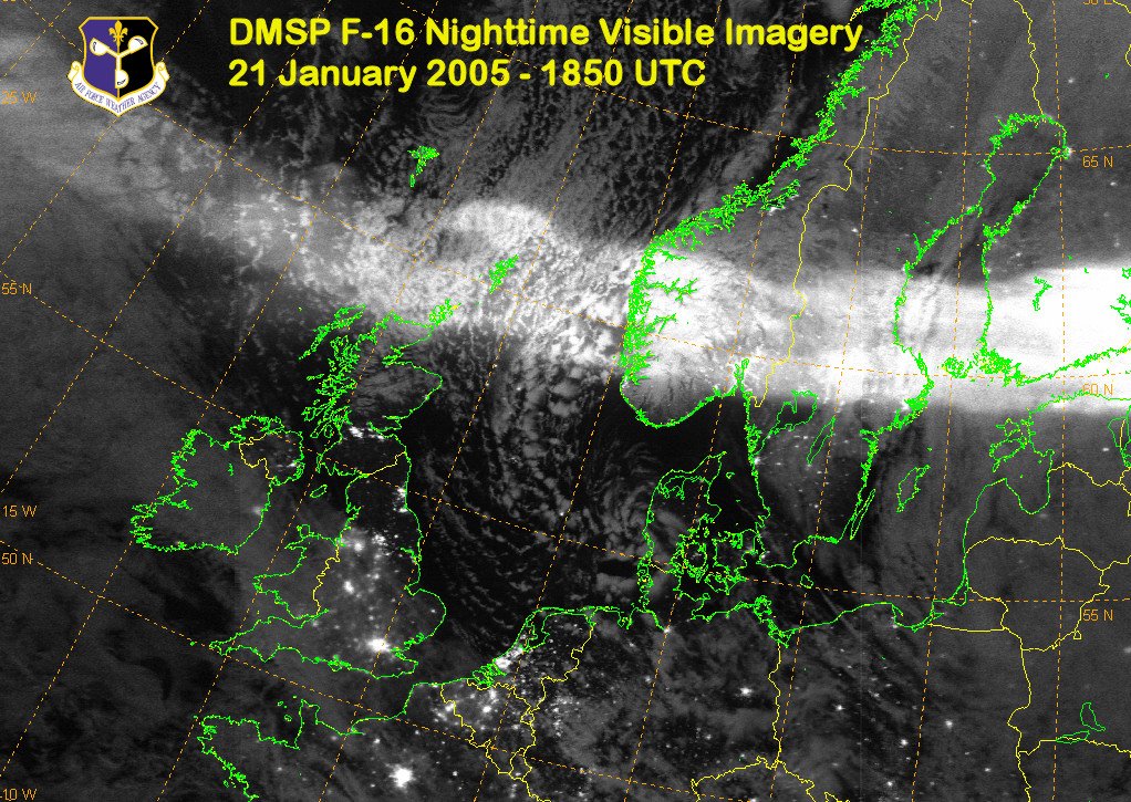
Contributed by Mark Conner of the US Air Force Defense Meteorological Satellite Program. A nighttime visible image depicting the aurora’s extent Friday evening in northwestern Europe. Image credit: Meteorological Satellite Applications Branch, Air Force Weather Agency.
5 years ago

Quakes Increasing at Alarming Rate
In 1997 there were only 3 notable quakes. http://neic.usgs.gov/neis/eq_depot/1997/
1998 saw 10 notable quakes. http://neic.usgs.gov/neis/eq_depot/1998/
In 1999 there were 13 notable quakes: http://neic.usgs.gov/neis/eq_depot/1999/
In 2000 there were 6 notable earthquakes. http://neic.usgs.gov/neis/eq_depot/2000/
In 2001 the number increased to 7. http://neic.usgs.gov/neis/eq_depot/2001/
By 2002 we jumped to 12 notable quakes. http://neic.usgs.gov/neis/eq_depot/2002/
Hol on, because in 2003 it was 39 notable quakes. http://neic.usgs.gov/neis/eq_depot/2003/
2004 calmed to just 39! http://neic.usgs.gov/neis/eq_depot/2004/
2005 Year to Date: We have had 6 notable quakes through the 19th of January. http://neic.usgs.gov/neis/eqlists/sig_2005.html At this rate, our annual “run rate” will top 115 for 2005!
5 years ago
Another Big Quake Shakes Wellington At 8am
[1] – A magnitude 5.5 earthquake was felt widely in the Wellington region just before 8am today, Geological and Nuclear Sciences (GNS) said. The quake occurred at 7.56am and was centred 30km deep within 5km of Upper Hutt. There have been no immediate reports of damage. A swarm of non-damaging small quakes, centered in the same location, occurred last year. See… Another Quake Jolts Wellington [2] and NZ researcher to study tsunami’s effect on land [3] . SCOOP LINK: Geonet: This Morning’s Upper Hutt Earthquake [4]
[1] – http://www.scoop.co.nz/mason/stories/SC0501/S00031.htm
[2] – http://www.scoop.co.nz/mason/stories/SC0501/S00031.htm
[3] – http://www.scoop.co.nz/mason/stories/SC0501/S00033.htm
[4] – http://www.geonet.org.nz/x2354133g_l.html
5 years ago
Updated as of Sun Jan 23 23:40:46 UTC 2005. DATE-(UTC)-TIME Latitude Longitude Depth Magnitude Comments
yyyy/mm/dd hh:mm:ss degrees degrees km
2005/01/23 22:36:08 35.95N 29.71E 31.9 6.1 EASTERN MEDITERRANEAN SEA
2005/01/23 20:10:12 1.25S 119.79E 10.0 6.3 SULAWESI, INDONESIA
2005/01/22 20:30:14 7.72S 159.46E 10.0 6.4 SOLOMON ISLANDS
2005/01/22 11:27:40 31.64S 177.98W 3.8 5.7 KERMADEC ISLANDS REGION
2005/01/22 02:57:07 22.18S 63.50W 523.0 5.1 SALTA, ARGENTINA
2005/01/21 17:58:56 33.93N 141.29E 10.0 5.2 OFF EAST COAST OF HONSHU, JAPAN
2005/01/21 17:54:34 5.12N 125.24E 173.5 5.6 MINDANAO, PHILIPPINES
2005/01/21 16:46:57 1.61S 80.89W 10.0 4.9 NEAR COAST OF ECUADOR
2005/01/21 16:15:05 1.28S 80.75W 10.0 4.5 NEAR COAST OF ECUADOR
2005/01/21 15:26:32 1.21S 80.89W 10.0 4.8 NEAR THE COAST OF ECUADOR
2005/01/21 14:28:22 24.66N 122.39E 105.0 5.3 TAIWAN REGION
2005/01/21 13:45:13 1.16S 80.78W 10.0 5.5 NEAR THE COAST OF ECUADOR
2005/01/21 12:45:32 34.20N 141.57E 10.0 5.4 OFF THE EAST COAST OF HONSHU, JAPAN
2005/01/21 11:39:33 9.77N 84.35W 19.3 4.2 COSTA RICA
2005/01/21 07:37:26 17.04N 146.95E 58.4 4.7 ALAMAGAN REG, N. MARIANA ISLANDS
2005/01/21 04:30:29 1.15S 80.74W 10.0 4.8 NEAR THE COAST OF ECUADOR
5 years ago
just stop, and fucking say whatever the fuck you’re getting at. This article spamming is getting old. What are you trying to say? No one else here knows either. I don’t even think you know what you’re getting at. So do yourself a favor and give it a rest.
5 years ago

5 years ago
HowardWCampbell?
The Mysterious Voynich Manuscript ancient text has no known title, no knwon author, and is written in no knwon language: what does it say and why does it have many astronomy illustrations?

5 years ago

This picture shows the Milky Way Galaxy with superimposed
mirror image of the “galaxy” from the Voynich Manuscript. The match is not perfect, but too close to be ignored. Copyright 2003 by World-Mysteries.com
Look! I can be a fucktard too!
Try and deciper my mysterious ramblings, which are actually a bunch of cut-n-pasted articles I haven’t read, but that looked cool. I’m not going to write anything of my own but some cryptic shit that means nothing, because I’m just trying to get a little attention.
5 years ago

Shopkeepers in Palu, on the Indonesian island of Sulawesi, examine their damaged stores after a magnitude 6.2 earthquake January 24, 2005. Nearly a month after the tsunami killed as many 174,000 in Indonesia’s Aceh province, an earthquake hit the city of Palu, killing one person and sending panicked tsunami survivors into the streets. REUTERS/Str
Tsunami panic in Indonesia’s Sulawesi as strong earthquake kills one
JAKARTA, Indonesia (Reuters) — A large earthquake shook Indonesia’s Sulawesi island early on Monday, damaging some buildings, officials said.
There were no immediate reports of casualties as a result of the tremor, which measured 6.2 on the Richter scale and hit at 3:10 a.m. Monday local time (2010 GMT Sunday), the meteorological and geophysics agency said.
Some homes in Palu, a town near the epicenter, had been damaged, an official at the agency told Reuters
The earthquake was followed by at least two aftershocks and the airport at Palu, 1,500 km (970 miles) northeast of Jakarta, had been closed, media reported.
The earthquake comes less than a month after a 9.0 magnitude quake off the Indonesian island of Sumatra on December 26 generated a tsunami which killed as many as 234,000 people around the Indian Ocean rim.
5 years ago

————————————————————————————————————————
Posted: January 24, 2005
1:00 a.m. Eastern
© 2005 WorldNetDaily.com
As cold weather sweeps across much of the U.S. and buries New England in several feet of snow, global warming hyperbole reached new heights today as an apocalyptic international report, “Meet the Climate Change,” warned the world is reaching a “point of no return” that will bring unprecedented famine and drought catastrophes.
The report was assembled by the Institute for Public Policy Research in Britain, the Centre for American Progress in the United States and the Australia Institute.
It warns the danger point will be reached when temperatures rise by 2 degrees Celsius above the average world temperature prevailing in 1750, before the industrial revolution – and the world may be only 10 years away.
While the global average temperature has only 0.8C, according to the data gathered by those advocating radical actions, the global warming lobby sees the glass half empty – cautioning the world has little more than a single degree of temperature latitude before the crucial point is reached.
In addition to famine and drought of spectacular proportions, the report warns of increased disease, sea-level rise and the death of forests.
“There is an ecological time bomb ticking away,” said Stephen Byers, former British transport minister and a close ally of British Prime Minister Tony Blair.
The report urges all G-8 countries to agree to generate a quarter of their electricity from renewable sources by 2025, and to double their research spending on low-carbon energy technologies by 2010.
The report comes just three weeks before the Kyoto Protocol, designed to deal with the climate change issue, takes legal effect on signatories Feb. 16.
The controversial Kyoto Protocol became binding on industrialized nations who have signed onto it after Russia reluctantly moved to ratify it.
But, Joseph Farah’s G2 Bulletin reports, Vladimir Putin’s personal economic adviser, Andrei Illarionov, said last summer Russia’s approval of Kyoto came under severe duress – an “all-out and total war on Russia” directed by Blair. He said the pressure included “bribes, blackmail and murder threats.”
Illarionov said global warming advocates refused to answer questions posed to the Intergovernmental Panel on Climate Change at a Moscow symposium. He claimed British science advisers tried to stop skeptics from being heard.
“When this attempt to introduce censorship … failed, other attempts were made to disrupt the seminar,” said Illarionov.
Illarionov said “none of the assertions made in the Kyoto Protocol and the ‘scientific’ theory on which it is based have been borne out by actual data. ... There is no evidence confirming a positive linkage between the level of carbon dioxide and temperature change. If there is such a linkage, it is of a reverse nature. ... The statistical data … are often considerably distorted if not falsified.”
While some in the U.S. have offered sharp criticism of the ideology driving the global warming crusade, none of the rhetoric has been as penetrating as Illarionov’s, who compared it “with man-hating totalitarian ideology with which we had the bad fortune to deal during the 20th century, such as National Socialism (and) Marxism.”
“All methods of distorting information existing in the world have been committed to prove the validity of these theories,” he continued. “Misinformation, falsification, fabrication, mythology, propaganda. Because what is offered cannot be qualified in any other way than myth, nonsense and absurdity.
Illarionov’s comments, made in a press conference, were quoted by the Moscow News but received little international attention.
He described the protocol as “one of the biggest, if not the biggest, international adventures based on man-hating totalitarian ideology, which, incidentally, manifests itself in totalitarian actions and concrete events, particularly academic discussions, and which tries to defend itself using disinformation and falsified facts. It’s hard to think of any other word but ‘war’ to describe this.”
Yuri Izrael, one of the three vice chairmen of the panel, said: “The Kyoto Protocol aims to impoverish our country, and not only us but our children and grandchildren.”
“There have been examples in our fairly recent history of how a considerable portion of Europe was flooded with the brown Nazi ideology, the red Commie ideology that caused severe casualties and consequences for Europe and the entire world,” said Illarionoc. “Now there is a big likelihood that a considerable part of Europe has been flooded with another type, another color of ideology, but with very similar implications for European societies and human societies the world over. And now we in Russia are facing a historical opportunity: Are we going to let the genie out of the bottle as the previous generations let the Nazi and Communist genies out of the bottles or not?”
While Putin agreed to participate in Kyoto, some observers believe he left Russia enough wiggle room for his country to back out of ratification.
Under the Kyoto Protocol, undeveloped Third-World nations – including China, India, Brazil and Mexico – will be free to produce whatever they want. Yet 82 percent of the projected emissions growth in future years will come from these countries. This is why many critics see is global wealth redistribution scheme rather than a real plan to improve the environment.
“The wealth of the United States is, and has always been, the target,” says Tom DeWeese, president of the American Policy Center. “The new scheme to grab the loot is through environmental scare tactics.”
He predicts international corporations, “who owe allegiance to no nation, will bolt America and move their factories, lock, stock, and computer chip to those Third World countries where they will be free to carry on production. But that means the same emissions will be coming out of the jungles of South America instead of Chicago. So where is the protection of the environment? You see, it’s not about that, is it?”
He points out that hidden in the small print of the treaty is a provision that calls for the “harmonizing of patent laws.”
“Now, robbing a nation of its patent protection is an interesting tactic for protecting the environment, don’t you think?” he adds.
DeWeese concludes: “The fact is that one person now stands between the global warming jackals and economic sanity — George W. Bush. Will he stand firm in his opposition to the Kyoto Protocol? Or will he capitulate to massive international pressure and sell America’s soul?”
5 years ago

UFO Sighting and Strange Signals reported again in Indian Ocean – sub tectonic experiment?
People are again reporting heavy UFO sighting in Nicobar Island, Andaman, India, Maldives, and Sri Lanka coastal areas. The animals in these areas are again showing strange behavior. The fishermen and their families this time are taking these signs seriously and are refusing to move near the ocean. The tribal people of Andaman Nicobar Island have again moved to the high grounds. The sea birds are also showing strange signals.
The UFO sightings happen at night with strange lights. The continuation of tremors of 6 or less Richter scale seems never ending. The ships traveling between India’s mainland and the Andaman-Nocobar Island as well commercial fishermen in Indian Ocean are reporting strange signals as well as jamming of their radio channels
5 years ago

Anti-gravity and Nano-technology research in India provide medical breakthroughs
India is advancing very rapidly in applications of Nano-technologies and anti-gravity techniques with some solid breakthroughs in Healthcare fields. Most of the research is still classified but indications coming out from sources close to the researchers are surprising.
5 years ago

5 years ago
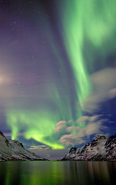
Bjorn Jorgensen,Ersfjord, Tromsoe, Norway Jan. 18
Controlling the ion characteristics in the atmosphere enables controlling the human mind and body
Have you ever thought why countries like Iraq surrendered almost without a fight.
Have you ever thought why Ukranians voters flipped and then flopped?
Have you ever thought how in China the Tibetans and the dissidents are kept under control?
In spite of strong urge to independence why Taiwanese elected a Government that will not ask for independence?
Do you know that human mind and body can be controlled using the ion characteristics in the atmosphere?
This is the subject of research in America, Russia, China, Japan, Europe and even in India. This technology is used to increase agricultural output, lower the morale of the enemy and even control the sentiment of the stock market players.
Most of the information is classified. Militaries of many countries are actively working on these technologies.
HIGH FREQUENCY ACTIVE AURORAL RESEARCH PROGRAM (HAARP) is one such program in America with collaborations of Canada. But many countries have the same kinds of projects. According to sources, HAARP is primarily a disinformation used by America. Actual projects under the American Department of Defense are completely classified.
Increasing the amount of positive ions makes the enemy soldiers reluctant to fight. The same can cause heart attacks in massive scale among a population. This same technology can be used to shield a country from any enemy missiles, aircrafts and electronic trajectories by frying all the electronics and making the incoming missile blind.
Solar storms cause such effects too. But human made ion changing experiments can cause massive effects in human mind and body.
Future weapons can be made of ion changers instead of guns. A would be rapist can be made to scare away, a thug can be made lethargic and a murderer or terrorist can be mentally neutralized.

5 years ago
THIS IS THE STORY WHICH PEOPLE DO NOT TRULY UNDERSTAND WHICH IS THE FUTURE FOR EARTH! I HAVE BEEN FOLLOWING THIS THEORY FOR OVER A DECADE
EVER SINCE I LISTEN TO BILL ON SHORTWAVE/.
KENT HAS FOLLOWED MY RESEARCH AND NOW IS POSTING MY FINDINGS THROUGH WHICH I POSTED ON GLP.
I SHARED THIS WITH GLP AND FOR THE PAST MONTH I HAVE BEEN USING THIS THREAD TO CONTINUE IT>\
\
I HAVE LOST MUCH OF THE DATA AT THE OTHER FORUMS, BUT I HAVE SOME OF IT STILL!!
I HAVE POSTED THIS FOR EVERYONE TO SHARE, BUT REALIZE IT WILL BE TEMPORARY SO KEEP CALLING ME NAMES, BUT VERY FEW WILL SEE THIS SET OF DATA BECAUSE TPTB DON’T WANT YOU TO>
CAN YOU COME UP WITH THE POINT OF ALL THIS AND SOLVE IT?
neverknwo

Non est ad astra mollis e terries via.—There is no easy way from the earth to the stars. Seneca
This is a documentation and study of the feasibility of creating a sustainable fusion reaction from an initial fission reaction on Saturn caused by a significant quantity of Plutonium-238 being inserted deep into the atmosphere. A fusion-ignited Saturn-sun would be the key to creating a human-habitable area on Titan. This report is the result of my intensive research on this subject since late 2002. I could not be so confident in my assertions if it were not for the additional key research of Jacco van der Worp, a Netherlands physicist, and former NASA Consultant, Richard C. Hoagland. I am sure I will be accused of being an alarmist, but I believe the information presented here will convince any open mind that there is at least some suspicious activity regarding NASA’s Galileo and Cassini missions.“~Exotic Titan, Saturn’s largest moon, like an early earth frozen in time~” 1
There are a few people in the world, who with endless imagination and creativity in union with massive resources and high technology have been playing “God” and secretly experimenting with changing the makeup of our solar system. There are not too many plans conceived that could be greater than creating a new star in our own backyard. One could almost claim godship upon success. Although at first I considered hiding what I knew so that the plan would go forward with full success, in the end my conscience overcame this desire since I knew there could be dangerous Earth implications for such a plan. Also keeping something this large a secret would be like finding a massive buried treasure while deep-sea diving and then never returning or telling anyone about it. (I still find myself wavering back and forth between wanting to see this spectacular plan unfold and not wanting it to happen knowing the potential consequences). I first stumbled onto the reality of this project while reading a famous conspiracy book entitled “Behold A Pale Horse” by William Cooper, former U.S. Naval Security Briefing Team member. Most people who came across Cooper’s short account (only a couple paragraphs) immediately discounted it, afterall, creating a star with a plutonium bomb sounds somewhat incredible at first, but this idea captured my imagination and completely fascinated me. I kept asking myself, “Why discount this?” With advanced knowledge and technology, I could see how some great minds would start to think about doing once impossible things. The more I checked into the facts, the more I became convinced that Cooper did not just make this up out of the blue. Too many coinciding events that he had predicted started manifesting themselves for it all to be just a tale. I could not keep quiet anymore about the plan despite my appreciation of the deep science, creativity, and innovation that made it possible. Also, despite the long odds of the event occurring, I felt compelled to warn the public because of the potential danger from the cast-off of matter that normally occurs in a star’s ignition. I will also make a case that there is a great deal of ritualistic symbology associated with the timing of this event, symbology that has strong ties to Freemasonry (old and new). I ask the reader to consider this scenario first: If a handful of the world’s greatest scientists were hired and paid top dollar by an organization with great wealth to solve a nearly impossible scientific problem and were allowed to work on it full time for years or even decades, do you think they would have a good shot at solving the problem, assuming they had the latest and greatest technology at their fingertips and were allowed to work in secrecy? My personal answer to this is “Yes, I believe they would have a very good chance!” One needs only to know the story of the “Manhattan Project” to see this. The logic of the Lucifer Project other than the extreme thrill of creating something so amazing, if not of sinister intent, could be that in order for humans to one day break out of this shell of Earth we must create more favorable conditions for traveling within our own solar system. For instance, could humans one day live on Titan? Maybe, but how do we warm it up? We play the part of creator and conduct solar system terraforming on a grand scale by turning Saturn into a small star that supplies Titan with the heat and light it needs to awaken. Turning one of our gas giants, like Saturn, into a star is the essence of the “Lucifer Project.” “The goal of fusion is in effect, to produce and hold a small star. It is a daunting and tedious research which is considered to be the most advanced in the world.” 2Star: A self-luminous, gaseous, celestial body of great mass which produces energy by means of nuclear fusion reactions, whose shape is usually spheroidal, and whose size may be as small as Earth or as large as Earth’s orbit.3
“Alea iacta est”.—The die has been cast. Caesar
The Cassini spacecraft is currently orbiting Saturn, but is likely to be sent into Saturn July of 2008. This report was written with the assumption that NASA will end Cassini’s mission the same way they ended Galileo’s by plunging it into the planet. The polar orbits that are currently scheduled allow an impact with Saturn on July 7 and approximately every week thereafter. The Cassini project is to be concluded no sooner than July 1. The Cassini Spacecraft is powered by two different means, its thrust propellant, used for trajectory adjustments, and its main power supply for running instruments. The latter is 238Pu, or Plutonium-238. This 238Pu is what is known as a radioisotope, or radioactive isotope, which becomes physically hot from its own radioactive decay. This heat is converted into electricity by a thermoelectric converter. At time of takeoff the spacecraft contained more than 72 lbs. of Plutonium-238 dioxide fuel within (216) 1 inch diameter x 1-1/2 inch long cylindrical pellets. Each pellet has about 1/3 lb. of plutonium dioxide fuel, most of which is plutonium-238 and a small amount being oxygen by mass. In addition, there are some minor amounts of 238Pu for other heater areas. The pellets are divided into three even groups of 72, each group within one RTG (Radioisotope Thermo-electric Generator).4 NASA has crashed a plutonium-carrying RTG into a similar atmosphere before which may have resulted in an explosion the size of Earth’s diameter near the equator of Jupiter as observed by many and imaged by Olivier Meeckers of Belgium on October 19, 2003. Space.com carried the story “Mystery Spot on Jupiter Baffles Astronomers.”5 The craft, Galileo, entered into Jupiter near its equator very close to where the “mystery spot” later developed (Diagram A). It is possible that if the explosion were larger or deeper, Jupiter could have reached ignition. The fact remains that a very suspicious bruise appeared on Jupiter 28 days after Galileo made its plunge there. It is important to mention that it is rare for a comet or meteor to impact Jupiter at the equator so it is unlikely this was the cause.
Saturn, like Jupiter and our Sun, is mostly composed of hydrogen and helium, in various gas, liquid, and metallic forms. The inner core may be composed of a somewhat solid rocky material. The average density of Saturn is only .7 g/cm3 (water is 1.0), but the pressure in the atmosphere and below is very intense. Towards the core of Saturn it is estimated the pressure could be millions of times that of Earth at sea level. Saturn’s atmosphere consists of about 97 percent hydrogen and 3 percent helium by volume and about 80/20 by mass.6 If Saturn had been 200 times more massive, it might have evolved into a star rather than a planet. Our solar system could have been a binary star system (more easily with Jupiter, of course). Besides hydrogen and helium, small amounts of methane, ammonia, and water vapor, and various hydrocarbons have been detected in Saturn’s atmosphere. Saturn has similar relative abundance of hydrogen and helium to the Sun itself. However, its core temperature is too low a value to trigger nuclear fusion.
I propose the magic trigger has been sought after and found!
The Trigger
IMPORTANT: The Shoemaker-Levy 9 (SL-9) comet event created enormous explosions, but no fissionable material was present to cause a nuclear reaction so the explosion temperatures (at max-7000ºC) were not high enough to cause a fusion reaction. The plutonium fuel cylinders in the RTG’s of Cassini (Diagram B) may act as Implosion Weapons and a fission “trigger” that may result directly in a fusion reaction that may be sustainable. In essence, a gas giant may be turned into a star in this way. A report in September, 2003 by physicist Jacco van der Worp of the Netherlands entitled “Could NASA Use Galileo to Create a Jovian Nagasaki”, states the same concerning Galileo’s plutonium at Jupiter: “Theoretically the avalanche reaction described for the Pu-238 pellets aboard Galileo can take place setting off an implosion-induced nuclear detonation.”7 Implosion Weapon: A weapon in which a quantity of fissionable material, less than a critical mass at ordinary pressure, has its volume suddenly reduced by compression, so that it becomes supercritical, producing a nuclear explosion. 8 Tom Van Flandern’s summary of “Planetary Explosion Mechanisms” states the following: “Indeed, nuclear fission chain reactions may provide the ignition temperature to set off thermonuclear reactions in stars (analogous to ignition of thermonuclear bombs).”9
While 238Pu is fissionable, it has been advertised as not fissile, or in others words this would mean it can produce a fission reaction that is difficult to sustain, but a 1962 test proved reactor grade plutonium (Pu-238 and Pu-240) to be fissile:
“The Department of Energy is providing additional information related to a 1962 underground nuclear test at the Nevada Test Site that used reactor-grade plutonium in the nuclear explosive. Specifically: -A successful test was conducted in 1962, which used reactor-grade plutonium in the nuclear explosive in place of weapon-grade [Pu-239] plutonium. –The yield was less than 20 kilotons. Background: This test was conducted to obtain nuclear design information concerning the feasibility of using reactor-grade plutonium as the nuclear explosive material. –The test confirmed that reactor-grade plutonium could be used to make a nuclear explosive. This fact was declassified in July 1977. … In short it would be quite possible for a potential proliferator to make a nuclear explosive from reactor-grade plutonium using a simple design that would be assured of having a yield in the range of one to a few kilotons, and more using an advanced design.” 10 In addition to this, a study conducted in part by Richard L. Garwin, a former JASON Group member, noted that all plutonium isotopes, even Pu-238 up to 80% purity, must be considered bomb making material. Garwin was involved in this study as well as other JASON Group studies, some of which can be accessed on the web at the references provided at the end of this report. 27 28 The Nuclear Control Institute (NCI) stated that reactor-grade plutonium could be more desirable for a simple bomb because it eliminates the need to use a neutron initiator.11 Also note the following in a report entitled “Plutonium-238, Use, Origin and Properties”: “If Pu-238 sits in the reactor long enough, it will absorb a neutron and become Pu-239 fuel.”12 Of course, Pu-239 is very fissile, in fact, it is the key component of most nuclear bombs. Since Cassini was launched in 1997, we know that its Pu-238 will have been sitting in the RTG reactors for more than 10 years by July 2008, maybe longer if the fuel cells were created beforehand. In an analysis of whether the fuel cylinders contain fissionable as well as fissile elements, we have to conclude that it is very possible. It has already been well demonstrated that a fission reaction can be sufficient to ignite a fusion reaction (i.e. the Hydrogen Bomb). A fission reaction generates high enough temperatures (high enough equals about 35 million degrees Kelvin) to reach the critical point required for a fusion reaction. This, however, does not necessarily mean a fusion reaction will occur. The right elements (various isotopes of hydrogen) must be present or created, so it is assumed. We do know Saturn is mostly composed of the same elements as the Sun, hydrogen and helium, but we are unsure if fusion and fission reactions would work exactly the same on Saturn as on Earth. However, conventional belief says Deuterium and Tritium (isotopes of Hydrogen) are necessary to accomplish fusion. Both are likely present deeper into Saturn. What is important to remember is the tremendous pressures inside Saturn are the key here when talking about implosion. We do know that implosion is what will occur to the fuel cylinders at some point in the impact. If the final implosion collapse of a cylinder happens suddenly enough, it could simulate an explosive-initiated implosion, the method normally used in a plutonium nuclear bomb. As mentioned earlier there is prior imaged evidence of an explosion from Galileo’s plutonium on Jupiter. An analysis by Richard C. Hoagland “Did NASA Accidentally ‘Nuke’ Jupiter?” states the same concerning a nuclear reaction on Jupiter: “It is this unique, dark ‘carbon’ signature – appearing as a dark black ‘splotch’ in the highest levels of the Jovian cloud belts which has given this entire, incredible scenario away ….”13Cassini is carrying 1.5 times the amount of plutonium dioxide (72 lbs) that Galileo was carrying (48 lbs) and Saturn’s mass is 30% of Jupiter’s mass. 48 is to 3.333 as 72 is to 1 translates into around 5 times the effective plutonium when the planet’s masses are figured in.
The plutonium pellets aboard are protected against unexpected pressures (not Saturn’s atmospheric pressures though). The upper crust of Saturn’s atmosphere is gaseous hydrogen and helium for about 500 miles in, followed by a more liquid substance of the two, and much further in (about half the radius), a more metallic version (so it is guessed). Cassini would go from 1/2 bar to 5 bars in just a few seconds upon entry into Saturn and then explode and burn up at which point its RTG’s, containing the Pu cylinders, will continue on. Eventually the RTG casings will deteriorate but the plutonium pellets will continue on, each having their own little heat shield of iridium and graphite, and start dramatically slowing down as the higher density atmosphere is encountered. It may take several days for the pellets to reach the point at which they implode. All that is required for fission from implosion to occur is for the final collapse of one of the graphite/iridium shells around one plutonium capsule to happen suddenly enough to prevent a fizzle, (a fizzle is a reaction that turns it into a dud). Since there are 216 separate cylinders, there are many chances to achieve a proper implosion and if one proper implosion occurs, it will act as a catalyst for others by showering them with neutrons as all of the cylinders will likely stay within 10’s of miles of each other. Each cylinder by itself will eventually reach the pressure point within Saturn to go critical if they are not spoiled somehow by then. The fuel cylinders would travel deep into Saturn, much more than the rest of the craft because they are designed to withstand extremely intense heat and pressure. They were designed this way in order to keep them intact in case of an accident upon launch and subsequent earth-atmosphere re-entry (also Cassini did a couple of Earth swing-bys for acceleration). Some members of the various agencies involved with Galileo and Cassini surely have considered the potential of a plutonium ignition and there is also evidence to suggest that a reaction is what is secretly hoped for, at least by a few. It was stated by William Cooper, (former United States Naval Intelligence briefing member in the early 70’s) that an elite group known as the “JASON Group”, or certain members of, had been hired full time to work on turning Jupiter into a small star. The “JASON Group” is comprised of the greatest science minds in the world.14 The Richard L. Garwin reports mentioned earlier further prove that the JASON Group does indeed exist. Saturn is much like Jupiter in composition and is actually a safer and more realistic target. Titan may be the big the big prize, being one of the few bodies in the solar system to potentially contain a significant amount of water and an atmosphere that could be very terraformable. Titan could be thawed out substantially with Saturn as its sun.Cassini’s orbit is scheduled to decay in July of 2008. Similar to Galileo’s plunge into Jupiter on September 21 2003, Cassini will most likely be plunged into Saturn with the exception that Cassini will likely go into the polar region of Saturn.15
In an Saturn ignition Earth would receive a miniscule amount of solar heating from a Saturn star, but brightness could be 100’s of times what Saturn is now. Around July/August 2008, the distance is about 10 AU or 1,500,000,000 km from Earth. More importantly though, Earth could receive a nasty shower of hot hydrogen a few weeks later, the real reason for concern.
In summary, most of the cylinders will survive the initial impact with Saturn’s upper atmosphere, because they are designed to do that, they have been successfully tested at an impact pressure of 19,600 PSI and higher than that for non-impact pressure.16 Each cylinder has a heat shield that can withstand temperatures in excess of 6400° F. The notion that Pu-238 cannot be fissile is very much in error, at least when talking about Saturn/Jupiter conditions. I will use Jacco van der Worp’s analysis and also remind the reader of the declassified 1962 test mentioned earlier. Pu-238 has a normalized reactivity of 1.1 and a spontaneous fission rate of 3440 neutrons per gram per second. This results in critical mass under normal conditions at 200 grams (this is why the cylinders are kept at 151 grams or 1/3 lb to avoid critical in Cassini). The cylinders will keep falling and may wander apart or stay together when the craft burns up – it doesn’t matter much because each cylinder will eventually reach critical on its own when the pressure builds enough in the fall into Saturn. Even if the cylinders wander apart, each one that is still intact will be ignited by a shower of neutrons from any cylinder that ignites. Around ¼ of the plutonium may fission because the surrounding Saturn pressure will maximize the results. With 72 lbs (32.7 kg) of plutonium this is equivalent to a 600 kiloton explosion. In comparison, the Nagasaki explosion used 7 kilograms, 1.2kg of which went into fission and caused a 22 kiloton explosion. This Saturn explosion would create temperatures of around 100,000,000° K because of the high density at the point of detonation. Even the sun’s interior is not that hot (only 30,000,000° K). This is way above the threshold for fusion to start. Saturn is similar in content to the sun and the same ingredients can produce the same result: ignition of the entire body of dense hydrogen. 7Regenerating, Recovering, and Creating Atmospheres
Our atmosphere is constantly regenerating to restore itself to the “normal” state. There have been traumatic periods, of course, when the atmosphere was under stress from the outside and from within, but the Earth has always recovered. Although a Saturn barrage could be deadly for a short time on Earth, a full recovery could take place in a matter of months. “On Earth, geological boundaries are accompanied by mass extinctions at five epochs over the last billion years. Two of the most intense of these, the P/T boundary about 250 Mya, and the K/T boundary (and the extinction of dinosaurs) at 65 Mya, are the most likely to be associated with the damage to Earth’s biosphere expected from a major planet explosion.” 9 “[On Earth] The ozone layer’s condition fluctuates between poor and excellent and the size of the holes measured in the ozone layer also goes up and down. Theoretically, given the appropriate conditions, the ceasing of using fossil fuels as a major supply of energy and fuel and the banning of the use of motor vehicles which do not meet strict emissions standards, the ozone layer would “repair” itself. The hole in the ozone layer, given the right conditions [would] “heal up”. It must be noted that natural events such as volcanic eruptions can also have a dramatic impact on the ozone layer. It is even thought that holes in the ozone layer existed long before mankind’s industrial revolution.”19 Titan, however, being at point blank range might require a few years to stabilize and its atmosphere and surface would dramatically change with Saturn as a sun. The dynamics could then exist for Titan’s atmosphere to be transformed into a more “earthly” state by getting rid of the conditions that produce the thick smog. Titan could get a kick start going from primordial to recognizably earthlike within a few decades with proper seeding and terraforming supplied by Earth. As this report is being written, data is being interpreted from the Huygens probe on Titan and the first images returned of Titan’s surface remind us of earthly coastlines with swampy deltas, although the muddy look may be due to liquid methane or pools of complex hydrocarbons. “Visible light cannot escape from the veil of orange smog that covers Titan’s surface. The moon’s dry cold atmosphere causes a 300 km thick layer of smog to build up. The smog, just like on Earth, forms when sunlight interacts with hydrocarbon molecules.”18 “Titan’s atmosphere, a murky mix of nitrogen, methane and argon, resembles Earth’s more than 3.8 billion years ago. Scientists think the moon may shed light on how life began. Finding living organisms, however, is a remote possibility. ‘It is not out of the question, but it is certainly not the first place I would look,’ said Candice Hansen, a scientist for the Cassini-Huygens mission. ‘It’s really very cold’. A lack of sunlight has put Titan into a deep-freeze, hindering chemical reactions needed for organic life.” 17 “Thus, while many of Earth’s familiar geophysical processes occur on Titan, the chemistry involved is quite different. Instead of liquid water, Titan has liquid methane. Instead of silicate rocks, Titan has frozen water ice. Instead of dirt, Titan has hydrocarbon particles settling out of the atmosphere, and instead of lava, Titanian volcanoes spew very cold ice.” 26 If the temperature were raised significantly at Titan, it would begin to more closely resemble an early Earth. The liquid methane (CH4) would turn to methane gas and precipitated carbon, the dirty ice (H2O) would turn to carbon, water, water vapor, and oxygen, nitrogen and argon are present, and hydrogen would also be very available, of course. Earth’s atmosphere is 78% Nitrogen, 21% Oxygen, and 1% Argon, Methane, Water Vapor, Carbon dioxide, Hydrogen and several other gases. The evaporated methane previously on the surface of Titan would be replaced by water from melted ice.A Bit About Lucifer
Magister mundi sum! – I am master of the universe!
Why is creating a star from one of our gaseous giants commonly known as the “Lucifer Project”? The potential star’s name was first dubbed “Lucifer” by A.C. Clarke in his novel “2010”. Lucifer is less of an actual deity and more of a concept representative of several ideas here. Lucifer, literally “light-bearer”, represents rebellion, claiming god-ship, bringing enlightenment, and mastering knowledge. Lucifer is a symbol of casting off the overlord and trusting the light from within, the concept of breaking out of the subservient shell of “God’s dominion” and claiming the universe as one’s own to conquer. 20 21 In general, the Luciferian message could be: “I am tired of worshipping a fairy-tale ‘God’ and leaving the future to the whim of idiots and fanatics. I will take the reins of the world into my own hands and guide it as I wish, as I may, as other will allow me to. I will set myself as a god. With the advantage of superior knowledge and the latest technology at my fingertips, I will rule as I see just. You may claim godship also and join me, or try to create the world in your own image. All you need to do is realize that you are also worthy and then attain the knowledge I have gained. If you will not realize and accept that you are a godlike creator then I have no pity for you and I will continue to dominate you until you come into the light.” As related to a Saturn Ignition, the message could be: “Let’s see if we can ignite something really big, like a planet! Let’s see if any ‘god’ stops us! We will be recognized as gods within our own circles if we succeed!” “Luciferian “spirituality” doesn’t rely on stripping man of his nature, but rather embraces his nature and his potential (godhood).” 21 “I [Lucifer] am the flame that burns in every heart of man, and in the core of every star. I am Life, and the giver of Life, yet therefore is the knowledge of me the knowledge of death…” -Aleister Crowley, The Book of the Law. 21Ancient Egyptian and Freemasonry Connections – Why Rho LEO in Virgo?
This section is a bit esoteric and delves into the possible symbolic reasons for trying to ignite Saturn as well as the possible effects on Earth. There are several similarities between the two missions Galileo and Cassini: 1) both have similar plutonium payloads (Cassini, much more), 2) both scenarios have moon candidates that could be new earths (Europa, Titan), 3) both will have impacted into a gaseous giant with conditions that will allow a nuclear detonation, 4) both crafts will have impacted while crossing under Leo’s front nearly above Rho LEO (Diagram C). This last one we will discuss more in detail now. This location in the sky, very near Rho LEO is in the tropical zodiac location VIRGO, despite being in the actual constellation of LEO. This particular star, Rho LEO, lies just below the ecliptic, (the general path of the planets). I suggest there may be a ritual of some sort going on here. Right Ascension 10.5 seems to be significant, (LEO is centered on RA 11, the 11th hour of the zodiac). The Greek letter Rho® is used as a variable for density calculations, and also a word to denote power as in Sigma-Iota-Rho (Prudence-Ideals-Power, the motto of Rhodes scholars), and Rho is synonymous with “Romi” which means Rome in Greek. The constellation LEO is also known to be one of power and kingship. Both impacts have been timed to occur while the planets in question are directly above Rho LEO, very near 10.5 Right Ascension. I propose that the significance here is three-fold. First of all, Rho LEO is referred to as the “lion’s right paw”. The “Lion’s Paw” in freemasonry has great importance as in the Hiram Abif allegory. In this story Solomon uses the Master Mason’s “Grip of the Lion’s Paw” to resurrect Hiram from the dead, which is symbolic of Hiram shedding his old life and waking up anew in his new understanding of the world, a baptism of sorts. This story is used in the initiation of Masonic members when they achieve the higher levels of Freemasonry. The story also echoes similar characteristics of the Osiris resurrection story of ancient Egypt. Many Freemasonry rituals are said to have origin in the ancient mystery religions of Egypt. Ancient hieroglyphs of Egypt feature a lion holding a symbol of some sort, possibly a planet, in his right hand over a prone body which is about to be resurrected “from a dead level to a living perpendicular.”22 This is part of the origin of the Hiram story. Secondly, the right paw of the lion is symbolic of the right paw of the Sphinx in Giza, where it is highly rumored that a vault, or network of vaults was discovered in the late 1990’s, but its contents not yet disclosed. A famous prophet from the mid-1900’s with a relatively high percentage of accuracy by the name of Edgar Cayce, said the “Hall of Records” would be discovered under the paw in the late 1990’s, but would not be revealed to the world until “the time was right”. The “Hall of Records” was to finally reveal to humanity their origins. I propose that the “right time” for this vault to be opened will be when NASA successfully ignites Jupiter, Saturn, or Neptune, while they are in the correct position of the sky, namely Rho Leo. This will clue the elitists to the fact that the time is soon for the final “baptism” of the Earth. At this point Earth will have less than a month to prepare for the likely ejecta from Saturn that would come after an ignition. Those who will figure it out in time and those “in the know” will have underground areas to go to for protection for at least 3 or 4 weeks during the shower, maybe more. The ejecta of Saturn may strip part of Earth’s ozone layer for a period of time leaving it defenseless against the shower as well as other cosmic ray bombardments. After a substantial wait, the bunker people could return to the surface to find the damage or “new reality” of Earth. What is odd is that this is also symbolic of dying and being buried under the ground, and then resurrected anew. In the 3 or 4 week wait time that it will take for Saturn’s cast-off to arrive at Earth, I propose that many amazing secrets will be revealed concerning our human origins, secrets brought up from the vaults of the Sphinx. Cayce also remarks that after the “Hall of Records” is revealed, Earth will suffer a major cataclysm. The puzzle fits together all too closely with Freemasons within NASA intentionally selecting a very specific location in the sky TWICE so far. I must conclude that the location is very symbolic and that symbol IS the LION’S PAW. Thirdly, there are also Isis overtones here as the location in the sky is known at this time as tropical VIRGO, the great mother. Isis was the sister/wife of Osiris and mother of Horus. Isis (Aset) is synonymous with VIRGO. VIRGO has also been associated with various other ancient goddesses. Taking this one step further I see yet another analogy: The Great Mother (Isis), having her egg (Saturn), fertilized by the craft (Cassini), after a significant wait (days to weeks), bears a great child (Horus/Osiris resurrected from the dead in the form of an amazing new star).
The Plutonium-lad Iridium/Graphite Cylinder – like the Monolith, the Alchemists’ Stone of Astronomical and Earthly Transformation
Another factor to consider is Hoagland’s assertion that Galileo’s plutonium started an explosion 10’s of miles wide and as the gas bubble from the explosion neared the surface of Jupiter 700 miles later, it had expanded to 1000’s of miles in diameter.13 Let’s look at an expanding bubble in Saturn. The cylinders are better built now, the density of the atmosphere compared to Jupiter is much less, and the pressure in Saturn doesn’t increase nearly as dramatically as in Jupiter. This will allow the cylinders higher speed and much deeper drops before imploding:
Assume 10’s of lbs of Pu isotopes ignite initially into a gas bubble sphere that is 50 miles in diameter 25% of the way to the center of Saturn, or 8500 miles into the polar area. Even if fusion does not start, this intensely hot gas bubble races to the surface at 1000 mph expanding rapidly to 100 times its current diameter the first 1000 miles increasing its size to 5000 miles diameter. The bubble continues to expand now but the rate of expansion is reined in for the rest of the trip. By the time the bubble reaches the surface it has slowed down dramatically but the diameter has increased to around 20,000 miles. Imagine taking a big spoon the shape of half of a sphere and 20,000 miles in diameter and scooping it out of the top of Saturn. This is the shape and size that would be affected in the most extreme scenario. About 1-2% of the volume of Saturn could be rapidly shoved aside or blown out. (Diagram D)
1. Displacement of volume.
2. Thrust follows to fill back in from all sides and from below.
3. General rush from all sides as a building avalanche of matter falling inwards to aid in replacement.
4. Further inward fall unstoppable, fusion heat builds.
5. Critical is reached and Saturn ignites.
What will this blowout cause? Even if fusion doesn’t start by initial fission heat, will Saturn begin to collapse in on itself having 1-2% of its volume suddenly displaced? I see several parallels here to the “2001”, “2010” novels/movies. Just before Jupiter ignites, a large cavity is seen increasing inside Jupiter (blowout cavity), it seems millions of black monoliths have converged in one area to cause this (iridium/carbon-cased plutonium cylinders?). The cavity increases to the point that Jupiter begins to collapse in on itself creating a situation where internal pressure and heat inside the planet increases 100 fold, at which point Jupiter ignites into a star via internal fusion.23 Is this yet another possibility for ignition other than straightforward fission heat resulting in fusion? In “2010” the monolith was a catalyst and symbol of transformation of humankind to the next level of existence, somewhat of alchemists’ stone for the human spirit. In a way, the black cylinders of Cassini seem to parallel this somewhat.When Jupiter ignited in the novel “2010”, an unrealistically tame shell of ionized hydrogen buffeted the spaceship on its way out into space, but depending on how much Saturn decides to shed (a rough estimate would be 10% of its mass)24, the ejecta may be much stronger than that for a much longer time.
Praemonitus pramunitus—Forewarned, forearmed
While amazing and grand, no doubt, I also find the Lucifer Project callous in regard for the people of Earth unless there is a more profound plan at work here that is beyond my knowledge. I have to conclude that the creators know the repercussions of a successful ignition of Saturn. This ignition can also be used as a religious tool, a “sign from the heavens”, possibly to give cause to ordain a great leader on Earth. If people are unaware of the artificial nature of the ignition they may be fooled by the claims. I still believe this event to be unlikely to happen despite the depth of research that I have committed to it. Regardless, my intention was to raise awareness on the subject so that in the event of an ignition, we would not be caught blindsided and would know the truth of how the star came to be.
—————————————————
Conspiratorial theory and timeline of events (speculations and wild conjectures are italicized)
1945 (July)— we ignite our first atom bomb
1950 — a team is assembled to study how this new technology can be used to create a star. Some of the world’s best scientists work on it secretly. This group is the “JASON Group” within the “JASON Society”, a think tank of geniuses that work full time to solve many major science problems.
1968 – Arthur C. Clarke promotes the “Lucifer Project” in books and movies entitled 2001 and 2010, using Saturn initially, but is later told to use Jupiter. (Once something spectacular occurs in a movie, it takes on a non-real possibility)
1972 – William Cooper sees or hears of the “Lucifer Project” during his time with the U.S. Naval Intelligence Briefing Team.
1983 – An unnamed craft or “lost” craft is secretly sent on a course to nudge a comet currently on a near collision course with Jupiter to a direct collision course with Jupiter.
1989 – Galileo is launched with two secret missions: 1) Collect information about the interior of gas giants using data from an upcoming comet collision with Jupiter (SL-9). 2) Impact Jupiter to ignite it, or if that fails, to collect more information about the interior by igniting as far beneath the atmosphere as possible, thereby bringing the interior to the surface.
1990 – William Cooper exposes the reality of the “Lucifer Project” in his book “Behold, A Pale Horse”.
1991 – Galileo’s main antenna supposedly deploys incorrectly. In reality, the antenna is fine and is being used to send the prime data to a few elite “higher-ups”.
1994 – Someone “in the know” helps Shoemaker spot the comet and the proper viewing is set up with Hubble and Galileo, etc. The high quality Galileo-SL-9 imagery and data is kept from the general public.
1994 – Data collected from the SL-9 collision is used to tweak the specifications of the Cassini RTG setup in order to improve the odds of a Saturn ignition.
1997 – Shoemaker is killed in a car crash in Australia. I am not aware of any evidence of foul play.
1997- Cassini is launched for Saturn with a tremendous load of Pu-238 dioxide (72 lbs!), many times the amount actually needed to run the craft’s instruments.
2003 – NASA scientists decide to plunge Galileo into Jupiter after claiming there is no other logical option after initially implying that the craft would be sent to deep space, crashed into a moon, or left in orbit.
2003 (July) Geographer, J.C. Goliathan publishes a report stating that a nuclear reaction is slightly possible if Galileo goes into Jupiter. 25
2003 (early Sept) Physicist, Jacco van der Worp publishes a report warning of what could happen if Galileo plunges into Jupiter citing Goliathan’s report and actually crunching the numbers to prove it. Jacco sites the low probability, but believes the risk is high enough to warrant a warning.
2003 (Sept. 21) Galileo dives into Jupiter at the equator. As was likely expected, nothing happens. Then 4 weeks later:
2003 (Oct. 19) Olivier Meeckers images a “mystery spot” the size of Earth with a streak trailing away near the equator of Jupiter. All other professional telescopes ignore the spot!
2003 (late Oct.) Richard C. Hoagland publishes a report detailing the entire amazing scenario showing that the “mystery spot” is most likely Galileo’s plutonium that had drifted down 700 miles into Jupiter at 1 mph for most of the trip!
2004- Cassini arrives at Saturn to study the system. The start of attempt #2.
2005 (early) – Cassini-launched Huygens probe studies Titan in depth revealing its primordial earthlike attributes.
2008 (early July to late July) – Cassini plunges into a polar region of Saturn in order to increase acceleration of gravity before impact (Saturn is very oblate). This will give the pellets a head start and a much greater penetration depth than if the equator were used. Also the polar region is less likely to have a storm brewing. A few days later, or maybe weeks later, the plutonium pellets reach crush depth and implode 15-25% of the way to the center of Saturn and igniting it entirely into a star. NASA does not have to officially deny responsibility because the question is never asked of them “Did Cassini cause this?” just as they were never questioned about the mystery Jupiter spot at the point where Galileo went in. The trick has been all along how to get the pellets in deep enough for a significant disturbance to occur. Saturn allows this with much less density than Jupiter and less of a radius to start with especially going into Saturn at its pole where the radius is 10% less than Saturn at the equator. Jupiter may have been a hopeful first try and more of a test or precursor to Saturn. Even A.C. Clarke and Stanley Kubrick originally envisioned Saturn as the best candidate. Another thing to note is that a Saturn ignition is much safer for Earth than a Jupiter ignition as far as ejecta disturbing our atmosphere. The amount of ionized hydrogen that reaches us from Saturn will be a fraction of that from a Jupiter ignition, but still risky . I estimate the mass of ionized hydrogen intercepted by the Earth to average .015 kg/m2/day for every square meter of the Earth for about two weeks and traveling at high speeds. During the last couple days heavier elements will reach the Earth in smaller quantities.
2008 (late July) – The new star is named, possibly Lucifer, or a derivative of that. The “sign from the heavens” is used to ordain a great world leader, or a leader who had just taken power prior to the event.
2008 (Jul/Aug/Sept) – After a few weeks of 24/7 talk of the implications, causes, effects, etc. of the new star, Earth begins to get showered with the ejecta from Saturn. The shower lasts 2 to 3 weeks and includes some heavier elements towards the end. This directly or indirectly kills millions of people and animals on Earth – a great boost for population control. Those “in the know” hide out in underground cities and bunkers for several weeks to several months until Earth’s ozone shell has recovered.
2009 – The new world reality sets in. After coping with the effects of the event, the survivors find that having a second sun is novel. Earth is completely changed, all infrastructures, political structures, and religions are thrust into chaos. The strongest surviving military force soon takes control of the Earth.
2010 – A call goes up to investigate and explore the new system of Saturn/Titan. 365/24/7 time and unlimited resources go into the new international venture. Terraforming plans start on a grand scale.
2033 – Humans set foot on an earthlike Titan.
References:
1. http://www.jpl.nasa.gov/multimedia/cassini-essay/html/6.html
2. http://www.monarchnote.com/basementpapers/papers/stack14_10.html
3. Merriam-Webster’s Collegiate Dictionary – Tenth Edition
4. http://saturn.jpl.nasa.gov/spacecraft/index.cfm
5. http://www.space.com/scienceastronomy/jupiter_dark_spot_031023.html
6. http://nssdc.gsfc.nasa.gov/planetary/factsheet/saturnfact.html
7. http://www.yowusa.com/Archive/Sep2003/Jupiter_attack/jupiter_attack.htm
8. Compton’s Interactive Encyclopedia, 1999
9. http://www.metaresearch.org/solar%20system/eph/eph2000.asp
10. http://www.ccnr.org/plute_bomb.html
11. http://www.nci.org/../pr/pr9199.htm
12. http://ourworld.compuserve.com/homepages/dlv/pu238.htm
13. http://www.enterprisemission.com/NukingJupiter.html
14. “Behold A Pale Horse” pg. 72, William Cooper 1991
15. http://saturn.jpl.nasa.gov/operations/saturn-tour.cfm
16. http://spacelink.nasa.gov/NASA.Projects/Human.Exploration.and.Development.of.Space/Human.Space.Flight/Shuttle/Shuttle.Missions/Flight.031.STS-34/Galileos.Power.Supply/RTG.Fact.Sheet
17. http://www.cnn.com/2005/TECH/space/01/14/huygens.titan/
18. http://sci.esa.int/science-e/www/object/index.cfm?fobjectid=35129
19. http://www.answerbag.com/c_view.php/1911#q_8728
20. http://www.lds-mormon.com/lucifer.shtml
21. http://noctuliusworks.satanicwebsites.com/custom3.html
22. “Ancient Operative Masonry and the Mysteries of Antiquity” pg. 25, S.R. Parchment
23. “2010” movie and novel p.299, Stanley Kubrick and A.C. Clarke 1982
24. http://www.new-physics.narod.ru/pagesEng/70e.htm
25. http://www.cyberspaceorbit.com/JUPFULLx.htm
26. http://www.esa.int/SPECIALS/Cassini-Huygens/SEMHB881Y3E_0.html
27. http://www.fas.org/rlg/980826-pu.htm NOTE: JASON Group contributer
28. http://www.fas.org/rlg
January 22, 2005
ADDITIONALLY
EDITOR DISCLAIMER: being one of the unwashed with no affiliation to politic, religion or lodge, I have no freakin idea if there are really a bunch of Geeks trying to blow Saturn to talcum powder or to ignite a new sun. But if there exists such an effort or such a crew of planetary-engineer buccaroos, tell you what, every human intuition in me shouts, this is a bad idea, A REALLY REALLY BAD IDEA! —Kent Steadman, ORBIT5 years ago
Here you will find some of the Galileo Crash Failures,
or cover-up.
Since the Crash I HAVE BEEN WATCHING NEWS STORIES that relate to and evidence of a Jupiter Trasformation.
Guess what ?
Within the last month a lot of info has been streaming in. I haven’t thrown it in this thread yet until I could add it when the time was right. Now is Right and I believe the planning continues by the Illuminati.
Will Thier be a Nuclear Reaction When Galileo will be directed to fall into Jupiter´s atmosphere on September 21, 2003?
Date: Wed, 3 Sep 2003 03:42:48 -0700 (PDT)
NUCLEAR REACTION WHEN GALILEO SPACECRAFT IMPACTS INTO JUPITER IN SEPTEMBER 2003 UNLIKELY, BUT POSSIBLE
http://www.cyberspaceorbit.com/JUPFULLx.htm
Unlikely things are just likely to happen when NASA is at the controls..How is the spacecraft powered?
http://www.jpl.nasa.gov/galileo/faqpow.html#howpower
Galileo uses two Radioisotope Thermoelectric Generators (or RTGs for short) to generate electrical power. The RTGs power the spacecraft through the radioactive decay of plutonium-238. The decay emits heat, which is converted into electricity for the spacecraft to “see, sense, hear, and speak.” Each RTG is mounted on a 5 meter long boom.
The spacecraft was able to generate 570 watts of electric power at launch; we expect that it will be able to produce 480 watts when the spacecraft actually arrives at Jupiter in December of 1995.
————————————————————————————————————————
What type of fuel do Galileo’s engines use?
http://www.jpl.nasa.gov/galileo/faqpow.html#howpowerGalileo uses monomethylhydrazine for fuel. The fuel has to be oxidized in order to ignite, so nitrogen tetroxide is mixed into the fuel right before a burn. There are two separate tanks of helium pressurant. In all, Galileo carried 932 kg (2,050 lbs) of propellant at launch.
————————————————————————————————————————
Why do we have to use plutonium? Why not use solar panels?
http://www.jpl.nasa.gov/galileo/faqpow.html#howpower
Spacecraft that travel at or within Earth’s orbit can use solar energy to power their instruments. However, at the great distance of Jupiter, the only feasible power source means using Galileo’s Radioisotope Thermal Generators (or RTGs for short). Galileo would need a minimum of 700 to 1,600 square feet of solar panels—a solar panel about the size of a house!
Unlike other power sources, the RTGs are insensitive to the freezing cold of space, and are virtually invulnerable to high radiation fields, such as Earth’s Van Allen belts and Jupiter’s magnetosphere.
For additional details, and a discussion of the safety review conducted on the RTGs, see What’s in an RTG?
http://www.jpl.nasa.gov/galileo/countdown/ http://www.jpl.nasa.gov/galileo/countdown/solar.htmlSince the 49.5 lbs of pu 238 is in the form of 144 irridium clad pellets, consider the possibilty that a dozen of the are pu 239 – would NASA lie to the unwashed masses?
http://www.skepticfiles.org/mys5/shutplut.htm
Clarke´s 2010 story is the documentation, but William Cooper was the prophet on this. He used to call this event the biggest event in human history. Of course he was killed shortly after 911. Wrote about it in Behold a Pale Horse and ranted on it regularly on the Hour of the Time.
When crew member Shannon Lucid (notice the name) released the Galileo spacecraft from the Shuttle, it began a six-year journey to that giant, colorful planet. Well that event is upon us.
We will soon know if Cooper was ahead of the curve on this one.
Check this thread out, THE LUCIFER PROJECT:
http://66.242.35.139/bbs/message.php?message=156773&topic=3
5 years ago
WHY WOULD CASSINI BE BLASTED BY DUST?

“Cassini Spacecraft “Sandblasted” By Dust From Saturn System In 2004”:http://www.spaceref.com/news/viewpr.html?pid=15968
New results from the Cassini mission indicate the spacecraft was pelted with sporadic bursts of interplanetary dust as it approached Saturn last year, according to a University of Colorado at Boulder space scientist.
Mihaly Horanyi of CU-Boulder’s Laboratory for Atmospheric and Space Physics said the dust particle bursts grew more frequent and intense as the Cassini spacecraft closed in on the planet from 40 million miles away in early 2004. Horanyi, also a CU-Boulder physics professor, said the dust might have escaped into space from the planet’s outer “A” ring or perhaps its icy moons, Dionne and Rhea.
CAN ANYONE SAY KABOOM?

“Saturn Moon A ‘Flammable World’”: http://www.cbsnews.com/stories/2005/01/21/tech/main668391.shtml
CBS News – Jan 21 8:30 AM
The European space probe to Titan, Saturn’s largest moon, has found a freezing, primitive world doused by rains of liquid methane.

AND IF THERE WAS A NUCLEAR REACTION ON THE SURFACE OF SATURN IN 2003,
WOULDN’T THERE BE CLUE’S TO A RADIATION EXPLOSIOIN?
Cassini Makes Saturn Discoveries
AP) The U.S.-European Cassini spacecraft discovered a new radiation belt around Saturn and has found that lightning in the ringed planet’s atmosphere is occurring much differently now than when NASA’s Voyagers flew by in the early 1980s, scientists said
5 years ago

Long Lost Star Catalog Found in Plain Sight
Sitting atop the broad shoulders of a seven-foot statue known as the Farnese Atlas is a sky globe depicting the nighttime sky. Scientists have been able to match the constellations shown on the globe with descriptions from Hipparchus’s only surviving work, Commentaries, and have concluded that this is a marble copy of his star catalog.
Hipparchus, who was Greek, was one of the greatest of the ancient astronomers and did his most important work between 140-125 BC. He calculated the length of the year to within six and a half minutes, developed a scale to rate the brightness of stars, was the first to record a nova, theorized on the motions of the Sun and Moon, provided high quality planetary observations and created the first ever catalog of 1,000 stars.
Perhaps his most important observation, and the one that provided the key to determining the Atlas held his catalog, was precession. Precession is the wobbling of Earth on its axis, like a spinning top as it slows down, over long periods of time. This wobbling is on a 26,000 year cycle, and causes the stars to appear to move across the sky. For example, Polaris, the North Star, is currently above the North Pole, but it has not always been so and will not be in the future.
5 years ago

Fermi nuclear power plant shut down
FRENCHTOWN TOWNSHIP, Mich. Officials say the reactor at the Fermi Two nuclear power plant was shut down this evening after a coolant leak was detected.
Officials with the Nuclear Regulatory Commission and D-T-E Energy says the Monroe County plant was NOT evacuated and the leak posed NO danger to the health or safety of plant workers or the public.
A spokeswoman for the N-R-C in Chicago says the plant was shut down without complications and nonessential workers were allowed to leave for the day.
Plant officials are trying to determine the cause of the leak and fix it. It wasn’t known when operations would resume.
A D-T-E spokeswoman says the reactor’s coolant remained at a normal level despite the leak. She added that the leaked coolant was NOT released into the environment.
5 years ago
——- Original Message ——-
From: “Larry W. Taylor”
Sent: Monday, January 24, 2005 2:31 PM
Subject: On The Phone With Stan Deyo
Jan. 24, 2005/ On the phone with Scientist
Stan Deyo today I talked with him about some
strange anomalies showing under East Texas,
Louisiana and Mississippi westward which is
part of the New Madrid Fault area. Stan told
me he is not sure these will indicate that
a Earthquake is coming or about to happen in
this area of southern US, however; it does
show that there is something happening here
and it deserves watching!
Stan & Holly Deyo Website:
Larry Taylor
5 years ago
——- Original Message ——-
From: “Larry W. Taylor”
Sent: Monday, January 24, 2005 4:56 PM
Subject: Deyo: ‘Quake Pressures Rising – New Data
Coming In!
Jan. 24, 2005/ Stan Deyo reports Earthquake
pressures rising according to new data coming
in now. Updates from Stan Deyo, possibly in
next few hours!
5 years ago

Meteorite hits Cambodia, sparks fires and prayers
26 Jan 2005 05:36:26 GMT
Source: Reuters
PHNOM PENH, Jan 26 (Reuters) – A 4.5 kg (10 lb) meteorite which landed in a former Khmer Rouge zone of northwest Cambodia started fires across rice fields and prayers from villagers who saw it as a divine omen of peace.
“Some farmers are angry with the rock because it caused fires and destroyed several hundred hectares of their paddy fields,” said Sok Sareth, police chief of Banteay Meanchey province, around 200 miles northwest of the capital, Phnom Penh.
“But others asked the police to leave it where it landed and put it on shrine to pray for peace,” he told Reuters on Wednesday.
The black lump of celestial rock sent villagers scurrying for cover when it thumped into the ground in the war-scarred southeast Asian nation on Monday morning.
“It made a noise like a bomb exploding,” Sok Sareth said. “It’s a good thing it didn’t land in the village or people could have been killed.”

Pictures of the meteorite were splashed across newspapers in the capital, but the item itself has been carried away by police pending scientific analysis.
Initial investigations by explosives experts still clearing the bombs and mines left behind from Cambodia’s years of civil war against Pol Pot’s guerrillas have not yielded many results.
“I asked my friend who works as deminer, but he has no idea what the rock is,” Sok Sareth said.
5 years ago

A Seismic Shift In Understanding How The Earth Got Its Gas
January 6, 2005 — Scientists studying volcanic activity in New Mexico, USA, have overturned a longstanding view of the origin of gases deep within our planet, according to a paper published in Nature this week.
The researchers, led by Dr Chris Ballentine from the University of Manchester, concluded that meteorite bombardment, after the moon was first formed, was the only way gases could have arrived so deep within the Earth – craters on the moon attest to the ferocity of this process.
The research, funded by the Natural Environment Research Council, has profound implications for our understanding of Earth’s early history.
Dr Ballentine said: “Before the moon formed the Earth had a massive atmosphere. Scientists have argued for decades that lava lakes underneath this atmosphere contained dissolved gases, in exactly the same way that carbon dioxide gas is pressurised into fizzy drinks.
“They believed currents in the magma oceans would take this dissolved gas deep into the Earth where the molten rock would eventually freeze, trapping the gases.
“But we know that a planet the size of Mars smashed into the Earth to form the moon. This devastating impact would have destroyed the early atmosphere and released any trapped gas, even from deep within the Earth,” he explained.
“So we asked the question, `why do volcanoes still spew out gases from so deep, to this day?’”
The team sampled volcanic gases in New Mexico. Uniquely, volcanic gases here contain very little air contamination and this allowed the team to measure rare gas isotopes, like neon, for the first time. These isotopes can be used to ‘fingerprint’ the origin of the volcanic gas.
The team found that these fingerprints were identical to gases found trapped in meteorites and not from an early atmosphere. The only way that these gases could have been added to the deep Earth is by continued meteorite bombardment after the moon was formed.
According to Dr Ballentine, tectonic activity on a huge scale must have dragged the gases trapped in the meteorites from the surface downwards.
Dr Ballentine’s work paves the way to acceptance of the theory that the whole mantle, the bit between the Earth’s crust and its core, convects like a pot of water on the stove – albeit very slowly – removing heat from deep within the Earth.
The team concluded that the whole mantle convective movement drives continental plate motion, controls the rate at which continents grow, and determines the amount of water, carbon and nitrogen that goes into and comes out of the Earth.
5 years ago
Texas A&M Oceanographer Challenges Plate Tectonics As Reason For Poles’ Shift

COLLEGE STATION – Millions of years before Carole King felt the earth move under her feet, the planet rapidly and drastically shifted on its axis, according to research by Texas A&M University oceanographer William Sager.
The earth pretty much rolled relative to its rotation axis, so that there was a 16- to 21-degree change,” Sager said of the “true polar wander” (TPW) shift that occurred approximately 84 million years ago. “It’s an odd event.”
It’s also an event that may offer an explanation other than drifting of the earth’s tectonic plates – the dominant theory since the 1960s – for the movement of the continents.
Although the findings by Sager and Anthony Koppers of the Scripps Institution of Oceanography don’t eliminate plate tectonics as a factor in the poles’ movement, Sager said their research suggests that tectonics alone would not have caused it. Their research appears in the current issue of the journal, Science.
“It’s an important piece of a puzzle that, taken with other data, can help change our understanding of how the earth works,” Sager said.
“The idea of true polar wander has been around for quite a while but it’s a difficult thing to see because you have to separate two competing motions,” he said. “On one hand, plate motion makes the axis appear to move, and on the other, the axis may actually shift. To separate the two, you have to somehow subtract out the plate motion and see what’s left.”
What was left suggests that the shift occurred as a result of rapid redistribution of matter within the planet’s mantle layer.
“What we’re saying is that the direction and the speed of the shift seems to be much faster than can be explained by plate motion,” Sager said.
The TPW shift could have caused rapid relocation of the continental landmasses (sufficient to put Dallas off the coast of Acapulco).
“The rapidity is one important thing,” Sager said, adding that plate motion occurs much slower than the event they observed. The planet’s plates move about 1 degree per million years.
“Our data set indicates that this polar shift took place at a rate between 5 and 10 degrees per million years,” he said. “Essentially it happens within the blink of an eye, in terms of geological time.”
The fact that the TPW shift occurred simultaneously with other geologic events – such as changes in plate motion, volcanic eruptions, changes in the earth’s magnetic field – all indicate the cause was something linking the planet’s deep interior with its surface, Sager added. “That’s why we think it was some kind of mantle overturn event.”
5 years ago

Current Time: Wed, 26 Jan 2005 20:06:22 UTC
Updated as of Wed Jan 26 18:56:37 UTC 2005. DATE-(UTC)-TIME Latitude Longitude Depth Magnitude Comments
yyyy/mm/dd hh:mm:ss degrees degrees km
2005/01/26 06:52:53 61.47N 151.50W 71.0 3.8 SOUTHERN ALASKA
2005/01/26 03:00:02 24.59S 179.67E 466.4 4.8 SOUTH OF FIJI ISLANDS
2005/01/25 22:21:57 69.78N 138.43E 10.0 5.1 EASTERN SIBERIA, RUSSIA
2005/01/25 18:54:27 49.34N 154.32E 135.2 5.3 KURIL ISLANDS
2005/01/25 18:37:11 11.00N 58.60W 10.0 4.8 NORTH ATLANTIC OCEAN
2005/01/25 16:44:11 37.69N 43.69E 3.6 5.9 TURKEY-IRAQ BORDER REGION
2005/01/25 16:30:38 22.52N 100.74E 10.5 4.9 YUNNAN, CHINA
2005/01/25 15:24:26 37.52N 43.70E 10.0 4.9 TURKEY-IRAQ BORDER REGION
2005/01/25 11:39:20 33.38N 45.81E 40.8 4.8 IRAN-IRAQ BORDER REGION
2005/01/25 09:46:30 14.55N 146.93E 10.0 4.9 ROTA REGION, N. MARIANA ISLANDS
2005/01/25 08:07:19 33.17N 45.97E 16.3 4.8 IRAN-IRAQ BORDER REGION
2005/01/25 07:33:51 43.28N 56.30W 18.0 4.1 NORTH ATLANTIC OCEAN
2005/01/25 01:38:43 12.98N 92.57E 30.0 4.3 ANDAMAN ISLANDS, INDIA REGION
2005/01/25 01:21:04 1.42S 80.89W 10.0 4.2 NEAR COAST OF ECUADOR
2005/01/25 00:03:53 33.35N 45.76E 51.1 4.5 IRAN-IRAQ BORDER REGION
5 years ago

U.S. Navy Surveying Waters Near Tsunami Epicenter
SINGAPORE (Reuters) – The U.S. Navy is surveying the Malacca Strait and coastal waters off Indonesia for signs that last month’s devastating Indian Ocean tsunami altered the sea bed under the world’s busiest shipping lane.
The USNS John McDonnell, a 208-ft specialist vessel, left Singapore on Jan.18 and was expected to complete its work by the middle of February in waters off Indonesia’s Aceh province near the epicenter of the earthquake that triggered the tsunami, U.S. Navy officials said.
The mission comes after the respected Marshall Islands Asia-Pacific maritime authorities issued an advisory that said the earthquake and tsunami may have been powerful enough to alter sea depths near Southeast Asia’s Malacca Strait.
Singapore media have published reports saying the tsunami may have reduced water depths in the Aceh sea bed by as much as 3,000 ft. But some experts say such a massive change may not be plausible but that the sea bed likely changed.
“When tsunamis travel into shallow waters, they may pile up between 10 to 20 meters (30 to 65 ft) of sediment but that won’t account for a thousand-meter change,” said David Higgitt, associate professor of geography at the National University of Singapore.
As part of its mission, the U.S. naval vessel will examine the ocean floor under the Malacca Strait, said U.S. Navy Lt. Patrick Starke, who is based in Thailand.
The narrow strait between Malaysia and Indonesia, with Singapore at its southern entrance, carries more than a quarter of world trade and almost all oil imports to Japan and China, and is one of Asia’s most strategically important channels.
Since July, the Indonesian, Singapore and Malaysian navies have conducted coordinated patrols of the 500-mile waterway through which about 50,000 commercial vessels sail each year.
“The survey started between Jan. 19 and 20 and is expected to end in the middle of Feb.,” said Commander Vince Giampaolo of the U.S. Naval Oceanographic Office.
SENSITIVE WATERS
The presence of foreign military in the Malacca Strait has traditionally been a touchy issue. The waters around the epicenter of the earthquake and tsunami, which fall within the Indonesian Exclusive Economic Zone, are another sensitive region. Continued …
5 years ago

Land goes from drought to flooding rain
“ABNORMAL WEATHER / GLOBAL WARMING / CLIMATE CHANGE / NEW ICE AGE”
Arid Australian interior linked to landscape burning by ancient humans
Climate change and the future of air travel
Scientist reveals a melting Alaska
EARTHQUAKES
Dozens of Earthquakes off Ecuador’s Coast Spark Fear
Three injured in China earthquake
Moderate undersea earthquake rumbles ocean bottom of Nova Scotia
Turkish Earthquakes Kill 2, Injure 22
Quakes harm psyches but cause little damage
WINDS / WINDSTORMS / TORNADOES
Waterspouts ‘skip over’ Channel
Fire, tornado left nine dead, more than 12,000 homeless in South Africa
FLOODING
River Erosion Affecting Mich. Lakes
COLD / ICE / AVALANCHES / SNOW
Avalanches Kill 4 at French Ski Resorts
Himalayan resorts cut off as heavy snows dump on North India
15 killed as blizzard lashes US
Blizzard in U.S. ranked among century’s worst
Cold snap grips western Europe
VOLCANOES
Papua New Guinea’s Volcano spews ash again
HEAT / FIRES
Fires continue to burn in Banda Aceh
MARINE RELATED / OCEAN THEME / TSUNAMIS
Drop in Lake Michigan’s level is man-made, report finds
Tsunami death toll nears 300,000
Scientist warns of tsunami threat to Australia
PARANORMAL / CRYPTOZOOLOGY / CAN’T CATEGORIZE

Town weathers triple disasters
5 years ago

Mission controllers cross their fingers whenever the Sun is stormy and their spacecraft have to fly over the South Atlantic. There, even satellites in low orbits suffer many hits by atomic bullets from the Sun. Troublesome faults occur in electronic systems and astronauts see flashes in their eyes. The Earth’s magnetic field, which shields our planet against charged atomic particles coming from outer space, is curiously weak in that region.
The South Atlantic Anomaly, as the experts call it, is one pressing reason why they are intensifying their exploration of the Earth’s magnetism. Denmark’s Ørsted satellite, launched in 1999, is dedicated to magnetic research, whilst Germany’s CHAMP mission (2000) measures both magnetism and gravity. These satellites show that the danger zone for satellites over Brazil and the South Atlantic is growing wider towards the southern Indian Ocean.
The Earth’s magnetic field is becoming generally weaker at an astonishing rate. When a French-Danish team compared Ørsted’s results for 2000 with those from an American satellite, Magsat, 20 years earlier, the decline in the field’s strength suggested that it might disappear completely in a thousand years or so. The experts wonder if our planet is preparing to swap its north and south magnetic poles around, as it has often done before during the Earth’s long history.
These and other mysteries about our magnetic planet will get the closer attention they deserve, in ESA’s forthcoming Swarm project. Three satellites will work together to measure the magnetic field and its variations far more accurately than ever before. The Swarm mission was proposed to ESA by Eigil Friis-Christensen (Copenhagen), Hermann Lühr (Potsdam) and Gauthier Hulot (Paris) with support from scientists in seven European countries and the USA. ESA selected the project in 2004 as an ‘opportunity mission’ in its Earth Explorer programme. All being well, Swarm will be operational by 2009.
After climbing into space on a single launcher, the satellites will adopt orbits passing over the Earth’s poles. Swarm A and B will fly side by side, simultaneously measuring the magnetic field from positions up to 150 kilometres apart in the east-west direction near the equator. Their orbits will at first be 450 kilometres above the surface, but by the end of the mission they will come as low as 300 kilometres, for more accurate measurements of magnetism originating from the Earth’s crust.
Swarm C will always fly higher, remaining at more than 500 kilometres altitude throughout the mission. Compared with its sisters, Swarm C will give simultaneous snapshots of the magnetic field over quite different regions of the Earth, and impressions of the same region at different times of day.
Separating the different sources of magnetism
Ordinary magnetic compasses obey the main magnetic field, produced by electric currents in the Earth’s core of molten iron. But in magnetic storms, compass needles wander. Since the 19th Century scientists have linked these storms to eruptions on the Sun. Many space ventures, recently including the ESA-NASA SOHO spacecraft and ESA’s four-satellite Cluster mission, have helped to clarify the solar connection.
We live in a protective bubble in space called the magnetosphere. At its boundary, gusts in a non-stop solar wind of atomic particles battle with the Earth’s magnetism. As a result, events in outer space make a continual but highly variable contribution to the magnetic field. So do electric currents in the ionosphere, the zone of free electrons and charged air molecules high in the atmosphere that’s best known for reflecting radio signals.
Other, much weaker patterns are overlaid on the global picture. In the Earth’s crust, many rocks have built-in magnetism that remembers the direction of the main magnetic field when they formed. This affects the field measured locally. By its subtle east-west comparisons Swarm will picture the magnetic field of the crust with unprecedented clarity. And even ocean water generates electric currents as it move in the main field, so that the ebb and flow of the tides have a slight magnetic effect.
As gauged by the satellites, the main field is roughly 6,000 times stronger than the rock magnetism of the ocean floor, and 30,000 times greater than the influence of the oceanic tides. Only with delicate measurements by satellite constellations, supported by ground stations, ships and aircraft carrying magnetic instruments, can scientists sort out all the patterns of magnetism from the different sources.
The most careful analyses reveal yet another effect. Magnetic variations drive electric currents in the mantle, the main region between the core and the crust. These in turn cause further magnetic changes, from which scientists can estimate the electrical conductivity of the mantle. This provides a check on the temperature of the material hidden deep in the Earth’s interior.
“What excites us is the huge scope of what we can study even with quite small satellites,” comments Nils Olsen of the Danish National Space Center in Copenhagen, who analyses Ørsted’s results while he helps to plan Swarm. “By making magnetic measurements in space we get new information about the Earth, from the molten core deep under our feet, through the mantle, to the crust on which we live. And then we go on upwards into the upper atmosphere, through the planet’s local space environment, and all the way to the Sun itself, which is the source of daily magnetic disturbances.”
Practical benefits
Solar storms can be fatal for satellites, and not only on account of radiation damage. The atmosphere inflates and low-orbiting spacecraft run into unexpected air resistance. Experts used to think it was just a matter of the air being heated by particles and electric currents in the regions around the poles, where auroras occur. Now a sensitive French-built accelerometer on the German CHAMP satellite has revealed heating by intense currents where the solar wind pushes towards the magnetic poles in daytime. The three Swarm satellites will investigate this new effect with accelerometers of their own.
Swarm’s operational lifetime, 2009-13, will coincide with the next expected peak of storminess on the Sun. Immediate practical benefits will centre on Swarm’s general monitoring of space weather, and the solar events affecting not just spacecraft and astronauts but technological systems on the ground as well. Magnetic storms can damage power systems and pipelines, whilst the changes in the magnetic field can mislead any navigational systems that use magnetic compasses. These include compasses operating underground to guide the drills used to find and recover oil.
For scientists, the biggest benefit of Swarm is that high-quality magnetic measurements provide a new way of ‘x-raying’ the hidden interior of planet. Earthquake waves and variations in the strength of gravity already provide a picture of the hot core, the rocky mantle that surrounds it, and the ever-active crust. But the picture is not yet clear enough for scientists to agree how the internal machinery of the planet really works.
“Magnetic measurements give a fresh point of view on the Earth’s interior,” says Roger Haagmans, who is responsible for solid-Earth science in ESA’s Earth Observation programme. “And Swarm will also investigate the puzzling changes in the Earth’s core that are responsible for the present weakening of the magnetic field. That’s already a matter of practical concern for many satellite operators. With a better idea of the reasons, we may know what to expect in the busy decades of spaceflight that we have ahead of us.”
5 years ago
Do you think it might be possible to just post selected excerpts from the articles you are linking to. Otherwise it’s a bit like Stream of Consciousness dribble
5 years ago

Indonesian Tsunami Probably Tripped by Exxon-Mobile Works
1-cubic-mile of natural gas extracted every four years at epicenter Aceh facility presents a smoking gun for man-made factor in 9.0 earthquake with accompanying tsunami that killed more than 225,000 people
5 years ago
WTF?
Would you like also my posts replies in streaming video?
5 years ago
You’re a nut!, You’re a quack!, You’re unbalanced!, Fucktard, etc….
REMEMBER Y2K?
Just a few of the nice names that we have been called over the last few years. And yes you knwo what?
Some of the ideas put forth on these pages are difficult for you Uniformitarians to accept. But it’s a funny thing how time changes things. It has been the practice of Uniformitarians to criticize and call names, and then after a few years they come around and start taking credit as if they have made a new discovery. They make it sound like it is a completely new idea or thought that originated with them alone. In the end I guess that’s alright – that’s another difference between “us and them”. We are not looking for fame or propriety. And there’s still why is there no new high def images from the HST on Hale Bopp? I think I’ve given up on ever seeing them.
But you never, ever never,
neverknwo about the NWO!
5 years ago

5 years ago

WHOOPS FALSE ALARM!!! Radiological Emergency in Downtown West Palm Beach
By WPTV staff.
January 26, 2005
West Palm Beach Fire/Rescue is investigating a leak of radiological material at 321 South Dixie Highway. The fire department recieved an initital report of smoke in the area with a high radiantion level at the Corodino Environmental Management Group. The fire department has evacuated a four block area between Quadrille, Olive, Dixie, and Fern. The evacuation has proceeded calmly and the fire department has not issued any type of advisory that would affected breathing or other health concerns. There have been no reported injuries.
5 years ago

The Cork is Off the Bottle – Nuclear Incident in Montana
A retired high-level government source was called yesterday to respond to a nuclear incident in Montana. Apparently the silo doors of numerous ICBM missiles were opened.
5 years ago
5 years ago
2005/01/26 22:00:42 2.91N 94.43E 10.0 6.1 OFF W COAST OF NORTHERN SUMATRA
2005/01/26 17:30:29 8.30N 93.98E 25.8 5.6 NICOBAR ISLANDS, INDIA REGION
2005/01/26 16:50:08 3.23N 96.23E 32.1 5.2 NORTHERN SUMATRA, INDONESIA
5 years ago
It wipes out the meteor-impact theory,
The Earth was not only far quieter after an event that scientists
refer to as the Great Dying, 250 million years ago, it might have
been a lot warmer than first believed.
Nearly all life on the planet – up to 96 per cent of sea life and 75
per cent of that on land – was wiped out, it was thought, by a huge
asteroid impact. However, new findings suggest it was global warming,
not a big rock, that triggered the largest recorded mass extinction.
5 years ago

5 years ago
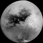
5 years ago

5 years ago

5 years ago

HUGE PACIFIC WAVE DAMAGES STUDENT VESSEL
Coast Guard rescuers are rushing to a “Semester at Sea” research ship with 990 people on board that lost power in roiling seas Wednesday afternoon in the North Pacific south of the Aleutians, officials said.
A 50-foot wave smashed through the bridge windows of the 591-foot MV Explorer around 2:30 p.m., pouring saltwater over electrical components on board and disabling all four of its engines, officials said. One engine was brought back online about an hour later.
5 years ago
AUSTRALIA could be hit by an earthquake measuring seven on the Richter scale because the plate we are on is breaking up, research has found.
Scientists from Melbourne University have discovered that the Indo-Australian plate is under considerable stress from its neighbouring plates in Indonesia and Asia.
The energy generated from the connection points between plates at Sumatra and Java are transferring back into our plate, causing immense tectonic stress. “This stress can produce earthquakes up to magnitude seven about every 30 years,” said Prof Michael Sandiford, from the university’s School of Earth Sciences.
5 years ago
Dark matter clouds may float through Earth
Small clouds of dark matter pass through Earth on a regular basis, suggest new calculations. The clouds may be remnants of the first structures to form after the big bang and could be detected by future space missions.
Dark matter interacts gravitationally with normal matter and appears to be seven times more abundant in the universe. But physicists do not know what the mysterious matter is made of or exactly how it is distributed through space.
Nonetheless, they have devised a number of hypothetical dark matter particles that were created in the big bang. These particles formed the universe’s first structures, where mysterious “quantum seeds” caused matter to clump more densely in certain spots. Dark matter slid into these spots which grew into structures that merged to become giant clouds – or haloes – with millions or trillions times more mass than the Sun.
5 years ago
The tribal people are saying that many miles below the earth’s surface, something is happening they never experienced before.
5 years ago
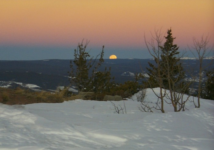
ISS TO BE COMPLETED BY 2010, JANUARY 27, (RIA Novosti) – The chiefs of US, Russian, Japanese and European space agencies conferred in Montreal, confirming specific accords to complete the International Space Station (ISS) by 2010, reads the NASA web site.
5 years ago
5 years ago
No thanks Streaming Vid is not necessary. Just excerpts so that the page will load in this decade. I mean the way you were previously going about it, I’d still be waiting for the page to load when, whatever natural disaster you are hinting at actually, takes place. I wanna know before it happens.
Oh and if I might make one more tiny request? Maybe you could actually write something on the subject yourself , you know, some personal comments, to tie it together for us slower ones.
Anyway, thank you for amending the way you post. Makes everything much easier to access
5 years ago

BLIZZARDS PARALYZE ALGERIAN CITY
The worst snowfalls in more than 50 years have paralysed Algeria’s capital, Algiers, and more than a third of the country, the authorities say.The bad weather is reported to have caused at least 10 deaths and hundreds of motorists have had to be rescued from their stranded vehicles.
5 years ago

Energy from the Vacuum – Concepts & Principles
Sent: Tuesday, December 28, 2004 1:20 AM
Hi Carter,
At least 60 to 70% chance it was artificially induced, probably by the Yakuza acting under coordination by the FSB/KGB.
The quake occurred on Dec 25 – KGB/FSB likes to choose dates of significance, so this may have been the “Christmas gift”. Took about a day to reach the shorelines etc. and do the damage.
Needed to be able to make on demand a quake of at least 9.0 intensity, for the planned use against the U.S. Demonstrated to the FSB/KGB that the Yakuza have achieved necessary skill and training for deliberate induction of that level quake intensity successfully produced on the ocean bottom.
Also a stimulus to the U.S. with a provocative demo, to see if the U.S. recognizes what it really is. The U.S. doesn’t.
Now fits several future intended uses against the U.S. at will, including the two main ones I put into the threat paper on the website.
So I suspect it was artificially induced as a multiple-purpose test by the Yakuza, acting on instructions of the FSB/KGB.
Best wishes,
Tom
5 years ago
28-JAN-2005 QUAKE REPORT
2005/01/28 22:37:07 34.71N 111.00W 5.0 4.0 ARIZONA
2005/01/28 19:18:51 7.99N 94.11E 19.9 5.4 NICOBAR ISLANDS, INDIA REGION
2005/01/28 17:49:40 8.07N 94.14E 30.0 5.4 NICOBAR ISLANDS, INDIA REGION
2005/01/28 17:31:58 8.02N 94.27E 30.0 4.8 NICOBAR ISLANDS, INDIA REGION
2005/01/28 17:26:18 7.98N 94.25E 30.0 4.9 NICOBAR ISLANDS, INDIA REGION
2005/01/28 17:04:53 8.18N 94.45E 30.0 4.9 NICOBAR ISLANDS, INDIA REGION
2005/01/28 15:46:44 1.15S 81.08W 10.0 6.2 OFF COAST OF ECUADOR
2005/01/28 13:26:14 36.05N 120.04W 8.9 3.0 CENTRAL CALIFORNIA
2005/01/28 13:03:26 36.05N 120.04W 9.7 4.0 CENTRAL CALIFORNIA
2005/01/28 12:37:10 8.05N 94.06E 14.1 5.4 NICOBAR ISLANDS, INDIA REGION
2005/01/28 09:26:17 1.20S 81.16W 10.0 6.1 OFF COAST OF ECUADOR
2005/01/28 08:47:18 7.98N 93.97E 30.0 5.1 NICOBAR ISLANDS, INDIA REGION
2005/01/28 08:29:46 7.88N 93.99E 20.7 5.3 NICOBAR ISLANDS, INDIA REGION
2005/01/28 07:49:18 8.07N 94.15E 30.0 5.5 NICOBAR ISLANDS, INDIA REGION
2005/01/28 06:13:26 7.98N 94.02E 30.0 5.7 NICOBAR ISLANDS, INDIA REGION
2005/01/28 06:10:31 7.94N 94.04E 42.2 5.5 NICOBAR ISLANDS, INDIA REGION
2005/01/28 03:31:27 8.19N 93.97E 30.0 5.4 NICOBAR ISLANDS, INDIA REGION
2005/01/28 03:26:28 7.95N 94.06E 30.0 4.8 NICOBAR ISLANDS, INDIA REGION
2005/01/28 02:25:05 14.17N 91.70W 79.5 4.5 GUATEMALA
2005/01/27 22:48:19 33.86N 117.74W 9.6 2.9 GREATER LOS ANGELES AREA, CA.
5 years ago

The Storm of all storms is coming
Well its officially coming . The Storm of the Millinium , is now pulling strength together in the North Pacific heading straight for California and continuing at a slow clip across the continental USA . Just as the last few clippers that came in that direction in the past few weeks . Look at the one Pounding the Eastern US Tonight 1/29/05 !
Downloaded an Active Destop Wallpaper Please visit for a further explanation of the features !
Look at the storm NW of California ?
Super Storm ?
5 years ago

5 years ago
Unusual events “unheard of in the history of seismology” have been recorded in the Andaman and Nicobar islands, with more than 120 such events being recorded in the last one month, according to seismologists.
The seismology department of the Bhabha Atomic Research Centre and the Earth Sciences Department of the Indian Institute of Technology here have recorded over 120 such unusual events in the islands following the December 26 earthquake measuring 8.9 on the Richter scale that triggered tsunamis which wreaked havoc in several parts of the country.
5 years ago
SATELLITE ZAPPED The solar explosion that sparked auroras over Europe also zapped NASA’s Gravity Probe B satellite, temporarily causing it to lose track of its guide star, IM Pegasi. Gravity Probe B is no ordinary satellite—it’s one of the most exquisite physics experiments ever attempted. Physicists are monitoring gyroscopes inside the spacecraft for wobbles that would indicate a subtle space-time vortex around Earth predicted by Einstein’s theory of relativity. Good news: Solar activity has ebbed and Gravity Probe B is back to normal.
5 years ago

SICKENING SOLAR FLARES Last week an X7-class solar flare from giant sunspot 720 sparked the most intense radiation storm in 15 years. “An astronaut caught outside [his spaceship] when the storm hit would’ve gotten sick,” says NASA’s chief radiation health officer. “But the dose would not have been fatal.” Get the full story from Science@NASA.
5 years ago

5 years ago

5 years ago
You’re a fucking obsessed idiot. God, give it a rest.
5 years ago
You’re a fucking idiot. God, give it a rest. You don’t know a goddamn thing about science, you’re obsessed with your crackpot little theory, and you’re doing nothing but posting any article your feverish little mind thinks might be connected to the grand theory you pulled out of your ass. You’re a fucking joke, an intellectual midget.
5 years ago
snak,
don’t be silly.
lighten up. have some fun.

http://www.vortexpluswater.com/free_thinking_and_free_energy.htm
5 years ago
5 years ago

5 years ago

5 years ago
Thank You SnarK, You’re right I’m not a scientist and your knwo Sorcerer’s Apprentice, either
5 years ago
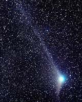
I don’t even know who Sorcha Fal is but I hereby dub her the
Prophetess of Doom. Omigosh, I think I need a fatty to celebrate!
Look, I searched the net to find out more about this woman, and came
up with all of these sites. What do you think?
Of course I am also going to seek out other news about this comet.
It’s a strange world folks & we must be open minded.
One thing which IS interesting is the story about the Morgan Sea
Gypsies:
Elders’ knowledge of the oceans spares Thai village from tsunami
Here are some other sites:
Unknown Energy Surges Continue to Hit Planet
Continuing Earth Changes Cripple American Submarine and Pose New Dangers for the American Continents
5 years ago
5 years ago
5 years ago

5 years ago

This is the same story echoed in every part of the world from India to America. Weather forecasting models are just failing and the variation patterns are so obvious that forecasters all over the world are scratching their heads.
World is experiencing some extreme weathers and weather forecasters in all parts of the world are just failing for reasons unknown to all.
5 years ago

A Miniature Star on Earth Scientists hope to build an experimental fusion reactor
Fusion reactions power the sun and stars. ITER aims to re-create that energy here on Earth by heating hydrogen gas to 100 million©C. In this inferno, hydrogen ions smash together, fuse into a larger ion—helium—and release energy. Physicists have already built reactors that can achieve fusion, but none has yet produced more energy than it consumes.
5 years ago
2005/01/29 20:01:55 8.08N 94.16E 22.2 5.2 NICOBAR ISLANDS, INDIA REGION
2005/01/29 19:46:35 63.05N 144.02W 1.0 4.3 CENTRAL ALASKA
2005/01/29 18:20:56 5.49N 94.31E 14.9 5.2 NORTHERN SUMATRA, INDONESIA
2005/01/29 16:37:09 60.12N 151.48W 45.0 4.4 KENAI PENINSULA, ALASKA
2005/01/29 14:45:33 15.68N 61.70W 10.0 4.7 LEEWARD ISLANDS
2005/01/29 07:41:29 37.89N 1.81W 1.9 4.4 SPAIN
2005/01/29 06:10:43 3.30N 93.68E 27.3 5.5 OFF W COAST OF NORTHERN SUMATRA
2005/01/29 05:44:12 13.10N 93.03E 20.0 5.6 ANDAMAN ISLANDS, INDIA REGION
2005/01/29 03:38:01 8.16N 94.23E 16.7 5.4 NICOBAR ISLANDS, INDIA REGION
2005/01/29 02:55:18 5.07N 94.71E 37.9 5.3 NORTHERN SUMATRA, INDONESIA
2005/01/29 02:30:06 34.07N 141.60E 51.6 4.8 OFF EAST COAST OF HONSHU, JAPAN
2005/01/29 01:50:22 7.86N 94.06E 30.0 5.1 NICOBAR ISLANDS, INDIA REGION
2005/01/29 01:38:59 34.70N 111.11W 5.0 2.5 ARIZONA
2005/01/29 01:13:44 7.31N 92.54E 34.1 5.1 NICOBAR ISLANDS, INDIA REGION
5 years ago
Remember giant sunspot 720?
If sunspot 720 holds together, it will turn to face Earth again in mid-February. Stay tuned.
5 years ago

5 years ago

5 years ago

5 years ago
NOTICE THE ENERGY INDUCTION RING IN COLUMBIA’s FINAL MISSION LOGO AND THE NASA LOGO?

![]()
Relativistic Partial Wave Analysis Using the Velocity Basis of the Poincare Group
The velocity basis of the Poincare group is used in the direct product space of two irreducible unitary representations of the Poincare group. The velocity basis with total angular momentum j will be used for the definition of relativistic Gamow vectors
Time Asymmetric Quantum Physics
5 years ago

5 years ago


The humans have discovered a time-travel channel which they call “The Gate.” It was built or created by a long-gone race of humans or aliens, and left on Earth millions of years before. It has been found and now utilized by humans, to go back in time, and some day, to go forward to future time.
.
Those people who choose to work are engaged mainly in “Snatch Teams” which utilize “The Gate” to travel backwards in time to “rescue” doomed humans, those on large ships about to sink without hope for the occupants, or airplanes about to crash. These rescued humans, who of course are in much better health than any humans of the year 2989 A.D., are kept in a state of hibernation, to be sent to the distant future to repopulate an Earth that without humans will have healed itself. This is the last real hope of mankind.
5 years ago
FLOODING AS A MEANS OF SOCIAL ENGINEERING FOR A NEW WORLD ORDER
When you see that the pattern of past deadly storms is consistent with the U.N. Map, your eyes should be opened to the fact that our weather may be controlled and utilized to create the social engineering so desired by the U.N.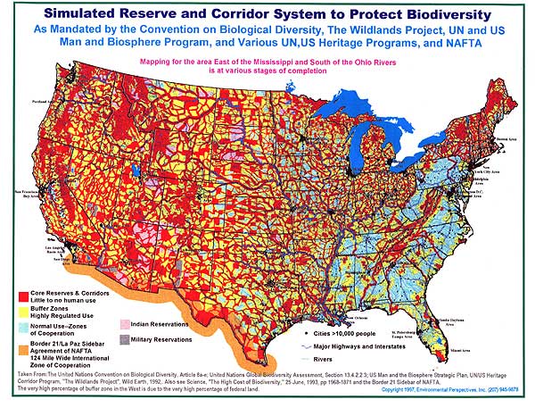
http://www.un.org/esa/sustdev/documents/agenda21/index.htm
http://www.un.org/issues/docs/d-socdev.asp
YOU ARE NOW ON
THE CUTTING EDGE
“(CNN) — The complex web of life on Earth, what scientists call ‘biodiversity, is in serious trouble. Biodiversity includes all living things that we depend on for our economies and our lives,’ explained Brooks Yeager, vice president of global programs at the World Wildlife Fund in Washington, D.C. ‘It’s the forests, the oceans, the coral reefs, the marine fish, the algae, the insects that make up the living world around us and which we couldn’t do without,’ he said.


No comments:
Post a Comment